IMAGES TAKEN NEAR TO
Calderpark Road, GLASGOW, G71 7RG
Introduction
This page details the photographs taken nearby to Calderpark Road, G71 7RG by members of the Geograph project.
The Geograph project started in 2005 with the aim of publishing, organising and preserving representative images for every square kilometre of Great Britain, Ireland and the Isle of Man.

There are currently over 7.5m images from over14,400 individuals and you can help contribute to the project by visiting https://www.geograph.org.uk
Image Map
Images are licensed for reuse under creativecommons.org/licenses/by-sa/2.0
Notes
- Clicking on the map will re-center to the selected point.
- The higher the marker number, the further away the image location is from the centre of the postcode.
Image Listing (30 Images Found)
Images are licensed for reuse under creativecommons.org/licenses/by-sa/2.0
Image
Details
Distance
1
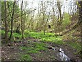
Seasonal Burn
This wee burn originates from more than one source in the areas of Baillieston and Garrowhill and falls into the North Calder Water at Channel Banks near Calderpark. Once a free flowing natural burn as can be witnessed by the gully it has cut out over the eons. Since the 1950s most of the water that came into it was diverted into the urban drainage system and it is now only a real burn in times of consistent rain , however this may change as a suds pond has been constructed nearby to facilitate run-off from new housing developments.
Image: © Robert Murray
Taken: 6 May 2005
0.07 miles
3
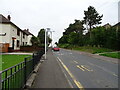
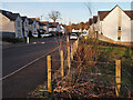
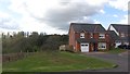
Calderbank Road, Broomhouse
There is a lot of housing development taking place or planned in this area. There is a show house on the left.
Image: © Richard Webb
Taken: 23 Apr 2012
0.11 miles
5
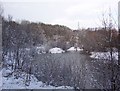
Webster's Pond
Named after the family who inhabited the then nearby Calderpark House up till about 1931. The pond is not natural, it appeared over a period of time after the closure of Calderbank Colliery and is the result of subsidence due to coal mining. The surrounds were considerably enhanced in the 1970s by Youth Opportunities work programmes [the famous 'Yoppers'] supervised by the nearby zoo staff in a bid to include it as part of that.
Image: © Robert Murray
Taken: 6 Jan 2003
0.12 miles
6
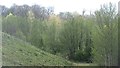
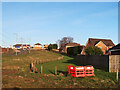
Woodland by the North Calder
Looking towards the site of the now closed Glasgow Zoo from a new housing development. Judging from road layouts there are plans to build more houses here.
There are some mounds and artificial looking topography here which may be a former landfill site.
Image: © Richard Webb
Taken: 23 Apr 2012
0.17 miles
7
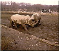
White Rhinos in the old Glasgow Zoo
Image: © Elliott Simpson
Taken: 25 Feb 1979
0.17 miles
8
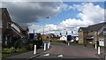
Carronhall Drive, Calderpark
New houses on the site of the old Calderpark Zoo which was opened in 1947 and closed in August 2003.
Image: © wrobison
Taken: 6 Mar 2022
0.17 miles
9
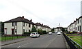
New housing
New housing development off Broomhouse Crescent. There is land awaiting development to the south.
Image: © Richard Webb
Taken: 23 Apr 2012
0.18 miles
10
Housing development at Ellismuir Park near Baillieston
A new development close to the M73, M74 and M8 motorways.
Image: © wrobison
Taken: 6 Mar 2022
0.18 miles