IMAGES TAKEN NEAR TO
Croftbank Crescent, GLASGOW, G71 7JD
Introduction
This page details the photographs taken nearby to Croftbank Crescent, G71 7JD by members of the Geograph project.
The Geograph project started in 2005 with the aim of publishing, organising and preserving representative images for every square kilometre of Great Britain, Ireland and the Isle of Man.

There are currently over 7.5m images from over14,400 individuals and you can help contribute to the project by visiting https://www.geograph.org.uk
Image Map
Images are licensed for reuse under creativecommons.org/licenses/by-sa/2.0
Notes
- Clicking on the map will re-center to the selected point.
- The higher the marker number, the further away the image location is from the centre of the postcode.
Image Listing (22 Images Found)
Images are licensed for reuse under creativecommons.org/licenses/by-sa/2.0
Image
Details
Distance
1
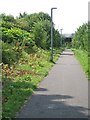
Cycle path, Uddingston
National Cycle Route 75 approaching the bridge carrying Lower Millgate over the West Coast mainline. Japanese knotweed is a problem here.
Image: © Richard Webb
Taken: 25 Jul 2008
0.10 miles
2
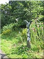
Peeing on a lamppost
Territorial scrawls on a National Cycle Route milepost.
Image: © Richard Webb
Taken: 25 Jul 2008
0.11 miles
3
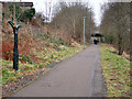
National Cycle Network Route 75 at Uddingston
A traffic free section next to the railway near Uddingston station.
Image: © wrobison
Taken: 9 Mar 2021
0.11 miles
4
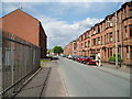
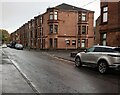
Crofthead Street
The tenement flats belong to West of Scotland Housing Association Ltd.
Image: © Gordon Dowie
Taken: 26 May 2010
0.14 miles
5
Tenements: Crofthead Street
Laighmuir Street on right
Image: © Jim Smillie
Taken: 7 Oct 2022
0.15 miles
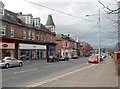
6
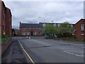
Uddingston, Lower Millgate
View towards the Main Street.
Image: © Robert Murray
Taken: 4 May 2012
0.17 miles
7
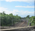
Rails to Glasgow
Just north of Bothwell from M74 northbound
Image: © John Firth
Taken: 9 May 2011
0.17 miles
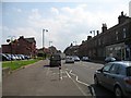
9
Main Street, Uddingston
The view is superficially similar to another contributor's picture of the Main Street (Image), but the present photograph was taken from a point about 500 metres further to the north. The people near the middle of the picture are standing beside the junction with Gardenside Street. The view is from the junction with Lower Millgate.
My thanks to John M, who pointed out that parts of the building near the centre of the picture, on the far side of Gardenside Street, where the people are standing, was used as a drill hall in the First World War. John also supplied the following useful Canmore link with further details: https://canmore.org.uk/site/333024/uddingston-163-main-street-drill-hall
Image: © Lairich Rig
Taken: 1 Apr 2005
0.19 miles
10
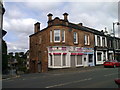
The corner of Gardenside Street and Main Street, Uddingston
According to http://canmore.rcahms.gov.uk/en/site/333024/details/uddingston+163+main+street+drill+hall/ there was a drill hall above the shops which, in 1914, was the base for "C" Company, 6th battalion Cameronians (Scottish Rifles).
Image: © Elliott Simpson
Taken: 21 Jul 2014
0.20 miles