IMAGES TAKEN NEAR TO
Muirhead Road, GLASGOW, G69 7UQ
Introduction
This page details the photographs taken nearby to Muirhead Road, G69 7UQ by members of the Geograph project.
The Geograph project started in 2005 with the aim of publishing, organising and preserving representative images for every square kilometre of Great Britain, Ireland and the Isle of Man.

There are currently over 7.5m images from over14,400 individuals and you can help contribute to the project by visiting https://www.geograph.org.uk
Image Map
Images are licensed for reuse under creativecommons.org/licenses/by-sa/2.0
Notes
- Clicking on the map will re-center to the selected point.
- The higher the marker number, the further away the image location is from the centre of the postcode.
Image Listing (57 Images Found)
Images are licensed for reuse under creativecommons.org/licenses/by-sa/2.0
Image
Details
Distance
1
![Baillieston, Muirhead Road [2]](https://s0.geograph.org.uk/geophotos/03/62/88/3628864_1bf922f0_120x120.jpg)
Baillieston, Muirhead Road [2]
The viaduct built by the Caledonian Railway in 1863 to carry horse drawn traffic. See also Image
Image: © Robert Murray
Taken: 25 Aug 2013
0.02 miles
2
Hangman's Brae, shelter belt
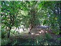
This photo was taken to record this little ancient woodland planted before 1750 (it appears on William Roy's map of the Lowlands of that year) that originally formed the boundary of the Blackyairds/Calderbank Estate. How much longer it will last is anybody's guess.
Image: © Robert Murray
Taken: 25 Aug 2013
0.03 miles
3
Weak bridge over railway
In Baillieston.
Image: © Stephen Sweeney
Taken: 30 Apr 2009
0.03 miles
4
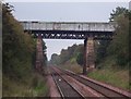
Baillieston, Muirhead Road Viaduct
Built in 1864 and still taking traffic - albeit restricted to one lane in recent years. Keen observers will note the right hand (southern) pier is thicker than the left (northern). The structure was built lop sided with the low end at the Hangman's Brae side where the road was cut out of the hill to reduce the severity of the gradient to assist horse drawn traffic.
Image: © Robert Murray
Taken: 4 Jul 2007
0.03 miles
5
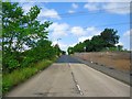
Hangman's Brae [3]
View north, up the brae.
Image: © Robert Murray
Taken: 25 Aug 2013
0.04 miles
6
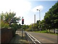
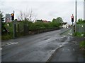
Baillieston, Muirhead Road
Traffic lights limiting traffic to one way at a time over the viaduct built in 1863.
Image: © Robert Murray
Taken: 25 Aug 2013
0.05 miles
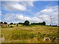
8
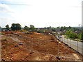
The Hangman's Brae [2]
Ground works which trees were cleared in order to make way for new roundabout. There has been extensive development works on Greenbelt land in this area due to Glasgow city council's determination to see expensive villas dominate the landscape.
Image: © Robert Murray
Taken: 25 Aug 2013
0.05 miles
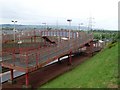
10
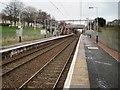
Baillieston railway station, Glasgow
Opened in 1993 by British Rail on the reopened line from Glasgow Central to Whifflet.
View north east after electrification, towards the original station site, around 500m further west, and Whifflet. For a pre-electrification view in the opposite direction some three years earlier, see Image
Image: © Nigel Thompson
Taken: 9 Feb 2017
0.05 miles