IMAGES TAKEN NEAR TO
Bargeddie, Baillieston, GLASGOW, G69 7UA
Introduction
This page details the photographs taken nearby to G69 7UA by members of the Geograph project.
The Geograph project started in 2005 with the aim of publishing, organising and preserving representative images for every square kilometre of Great Britain, Ireland and the Isle of Man.

There are currently over 7.5m images from over14,400 individuals and you can help contribute to the project by visiting https://www.geograph.org.uk
Image Map
Images are licensed for reuse under creativecommons.org/licenses/by-sa/2.0
Notes
- Clicking on the map will re-center to the selected point.
- The higher the marker number, the further away the image location is from the centre of the postcode.
Image Listing (36 Images Found)
Images are licensed for reuse under creativecommons.org/licenses/by-sa/2.0
Image
Details
Distance
1
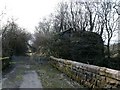
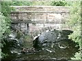
The Old Aitkenhead Bridge
A double arched span bridge which carried the B757 over the North Calder. The abutment of the viaduct which carried Bredisholm Railway over the river here is on the left. See also www.geograph.org.uk/photo/1758591
Image: © Robert Murray
Taken: 17 Mar 2010
0.02 miles
2
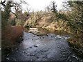
North Calder Water at old mill
The old Bredisholm mill was situated on the left bank of the river here.
Image: © Robert Murray
Taken: 17 Mar 2010
0.02 miles
3
Old Aitkenhead Bridge
Taken purely to compare with Image taken five years ago.
Image: © Robert Murray
Taken: 16 Jun 2015
0.03 miles
4
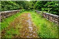
Old Road at Aitkenhead
This road was formerly the B757 before this section was closed. The new A752 was aligned along a more direct route.
The structure to the left is an embankment of the Bredisholm mineral railway which looped off the NBR Shettleston Bothwell line in the south and connected with the Caldedonian Railway's Rutherglen to Coatbridge branch, servicing the pits in between up till 1934 when the last one closed. See also www.geograph.org.uk/photo/1758599
Image: © Robert Murray
Taken: 17 Mar 2010
0.03 miles
5
Aitkenhead Bridge
Taking the old road over the Calder still flowing in spate.
Image: © Robert Murray
Taken: 9 Sep 2009
0.04 miles
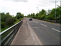
6
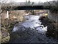
Bridge over Calder Water
This bridge takes the A752 Gartcosh to Uddingston road across the North Calder at Aitkenhead, it replaced the Aitkenhead bridge (which the photographer took the photo from) in the early 1970s.
Image: © Robert Murray
Taken: 17 Mar 2010
0.05 miles
7
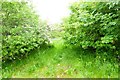
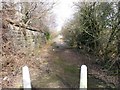
Old Mineral Line
Track bed of the old Bredisholm railway built in 1850 which connected the original Bredisholm pits to the Drumpeller Railway a half mile away near Luggie Bridge from where coals were carried uphill to the canal port at Cuilhill for transhipment onto barges. Horses were used to pull the wagons on this line before pugs were introduced in the 1870s.
Image: © Robert Murray
Taken: 16 Jun 2015
0.06 miles
8
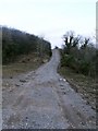
Contractor's access track
Laid in 2009 by contractors doing some work on sewage pipes.
Image: © Robert Murray
Taken: 17 Mar 2010
0.06 miles
9
A752 at North Calder water
Taken from the road bridge over the river.
Image: © Gordon Dowie
Taken: 26 May 2010
0.08 miles
10
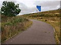
Cycle path alongside M8
Leading up off the A752
Image: © Jim Smillie
Taken: 30 Aug 2022
0.09 miles