IMAGES TAKEN NEAR TO
Heatheryknowe Road, GLASGOW, G69 6TZ
Introduction
This page details the photographs taken nearby to Heatheryknowe Road, G69 6TZ by members of the Geograph project.
The Geograph project started in 2005 with the aim of publishing, organising and preserving representative images for every square kilometre of Great Britain, Ireland and the Isle of Man.

There are currently over 7.5m images from over14,400 individuals and you can help contribute to the project by visiting https://www.geograph.org.uk
Image Map
Images are licensed for reuse under creativecommons.org/licenses/by-sa/2.0
Notes
- Clicking on the map will re-center to the selected point.
- The higher the marker number, the further away the image location is from the centre of the postcode.
Image Listing (6 Images Found)
Images are licensed for reuse under creativecommons.org/licenses/by-sa/2.0
Image
Details
Distance
1
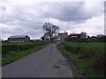
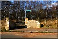
Heatheryknowe Farm
No longer a working farm - which it was until very recently - but now some kind of small business centre. The masonic lodge in nearby Bargeddie takes its name from this farm.
Image: © Robert Murray
Taken: 13 May 2010
0.02 miles
2
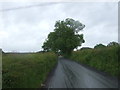
Commonhead Road
Heading south east towards the A752.
Image: © JThomas
Taken: 29 Jun 2017
0.06 miles
4
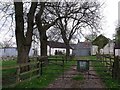
Commonhead Farm
On the edge of the urban sprawl it is now derelict and up for sale. For 150 years owned and farmed by successive generations of the Mason family.
Image: © Robert Murray
Taken: 13 May 2010
0.12 miles
5
Gateway to the Moss
At Commonhead Road. These days it is referred to as an LNR - Local Nature Reserve. Most of the moss has at one time been harvested for the peat. In historical terms this land was 'Common' but in the mid Eighteenth century local landed proprietors took advantage of the law to divide it up between them. Refer North Lanarkshire Council Archives. Motherwell Heritage Centre.
"Where Four Laird's waters meet, you'll find the fairies".
Image: © Robert Murray
Taken: 19 Mar 2016
0.13 miles
6
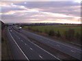
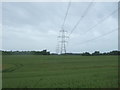
Looking south down M73 from Commonhead Road
Image: © Chris Upson
Taken: 26 Feb 2006
0.25 miles