IMAGES TAKEN NEAR TO
Rhindmuir Road, GLASGOW, G69 6AY
Introduction
This page details the photographs taken nearby to Rhindmuir Road, G69 6AY by members of the Geograph project.
The Geograph project started in 2005 with the aim of publishing, organising and preserving representative images for every square kilometre of Great Britain, Ireland and the Isle of Man.

There are currently over 7.5m images from over14,400 individuals and you can help contribute to the project by visiting https://www.geograph.org.uk
Image Map
Images are licensed for reuse under creativecommons.org/licenses/by-sa/2.0
Notes
- Clicking on the map will re-center to the selected point.
- The higher the marker number, the further away the image location is from the centre of the postcode.
Image Listing (17 Images Found)
Images are licensed for reuse under creativecommons.org/licenses/by-sa/2.0
Image
Details
Distance
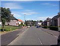
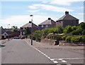
2
Swinton Avenue
Built in the 1980s the developer tagged the area as 'Rowanbank' but locals call it Swinton.
Image: © Robert Murray
Taken: 8 Aug 2005
0.17 miles
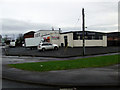
3
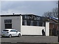
The Swinton Tavern
On Swinton Road which is now cut and just a side road. It has been replaced by a modern bypass type road to the west.
Image: © Richard Webb
Taken: 23 Apr 2012
0.18 miles
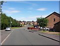
4
Businesses on Swinton Road
Viewed from Easterhouse Road.
Image: © Thomas Nugent
Taken: 28 Jul 2021
0.18 miles
5

The Swinton Tavern
At the junction of Easterhouse and Rhindmuir Roads at Baillieston.
Image: © M J Richardson
Taken: 18 Aug 2010
0.18 miles
6
Swinton Crescent
The first three houses to be completed in this Housing Improvement Scheme of the early 1920s. Interestingly built using bricks supplied from Germany as part of the War Reparations treaty. This area was originally named North Baillieston.
Image: © Robert Murray
Taken: 8 Aug 2005
0.18 miles
7
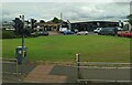
Businesses on Swinton Road
Viewed from Eastherhouse Road.
Image: © Thomas Nugent
Taken: 28 Jul 2021
0.18 miles
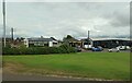
8
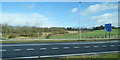
Railway and motorway near Easterhouse
The line between Easterhouse and Blairhill, viewed from the M8 motorway.
Image: © Thomas Nugent
Taken: 23 Feb 2020
0.19 miles
9
The Swinton Tavern
Near Easterhouse railway station.
Image: © Thomas Nugent
Taken: 6 Jan 2013
0.19 miles
10
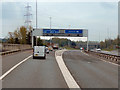
M8, Swinton (Junction 8)
The exit slip road from the M8 (junction 8) for the M73/M74 motorways.
Note the typical “Glasgow-type” sign gantry advising of the approaching junction 15 as the slip road from junction 16 joins from the left. With the following distinctive elements:
• Near and offside support legs (basically 2 rectangular hollow sections with base plates to allow connections to the foundations)
• A Main Frame (made up of rectangular hollow sections) - Over clad on the front and rear.
• A Sub Frame (made up of smaller hollow sections and welded to main frame).
• A Sign Face - acrylic sheets hung from the front of the sub frame over its full height.
• Internal Electrics - sign lighting provided through the use of several dozen fluorescent battens.
Gantries of this type were erected as part of the construction of the Kingston Bridge and its approach roads in 1970 and they are now a familiar sight on the network around Glasgow.
More information on “Glasgow Style Gantries” at http://www.glasgows-motorways.co.uk/glasgow-gantries/4578281645 (Glasgow’s Motorways)
Image: © David Dixon
Taken: 20 Apr 2012
0.20 miles