IMAGES TAKEN NEAR TO
Caisteal Road, GLASGOW, G68 0FS
Introduction
This page details the photographs taken nearby to Caisteal Road, G68 0FS by members of the Geograph project.
The Geograph project started in 2005 with the aim of publishing, organising and preserving representative images for every square kilometre of Great Britain, Ireland and the Isle of Man.

There are currently over 7.5m images from over14,400 individuals and you can help contribute to the project by visiting https://www.geograph.org.uk
Image Map
Images are licensed for reuse under creativecommons.org/licenses/by-sa/2.0
Notes
- Clicking on the map will re-center to the selected point.
- The higher the marker number, the further away the image location is from the centre of the postcode.
Image Listing (74 Images Found)
Images are licensed for reuse under creativecommons.org/licenses/by-sa/2.0
Image
Details
Distance
1
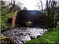
Aqueduct parapet
Part of the Castlecary Aqueduct, which carries the Forth and Clyde Canal over the Red Burn.
Image: © Richard Sutcliffe
Taken: 21 Mar 2020
0.09 miles
2
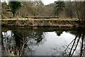
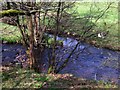
Forth and Clyde canal passing over Red Burn
The Forth and Clyde canal is carried over Red Burn by an aqueduct. The Red Burn descends the steep-sided, tree-lined glen in the background to pass under the canal.
Image: © Mark Nightingale
Taken: 11 Nov 2009
0.09 miles
3
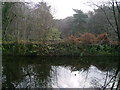
Bonny Water and Red Burn confluence
A closer view of the confluence in http://www.geograph.org.uk/photo/2351507 underlines the fact that the Auchincloch/Bonny is a wee burn joining a river.
'Reports of John Smeaton' (the Forth & Clyde Canal engineer) pp.42, 1764, pub. London, 1812;
"Red Burn, which together with Auchinclough, forms the river Bonnie, a little above Castlecary Bridge."
See also > Image
Image: © Robert Murray
Taken: 9 Apr 2011
0.11 miles
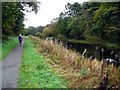
4
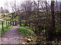
Forth & Clyde Canal path network
The county boundary to the right with the path leading uphill to the canal towpath.
Image: © Robert Murray
Taken: 9 Apr 2011
0.11 miles
5
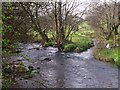
Woodneuk aqueduct and Red Burn
Everything you see in this photo is man made - including the river.
The aqueduct, built in 1770 carries the Forth & Clyde canal. The canal Resident Engineer, Robert Mackell, under pressure to trim costs diverted the Red Burn from its natural route which went north-west to join the Bonny Water to a directly northern course to enable a shorter span for the aqueduct over the river.
Image: © Robert Murray
Taken: 9 Apr 2011
0.11 miles
7
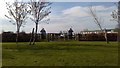
Castlecary Roman fort
The two Roman soldiers guarding the gate mark the entrance to the site of the Castlecary Roman fort and annexe, one of only two forts along the Antonine Wall to have stone ramparts. Unfortunately, very little is visible of the fort today.
Image: © Euan Nelson
Taken: 8 May 2016
0.12 miles
8
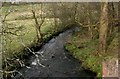
Red Burn
Seen from the Castlecary Aqueduct, which carries the Forth and Clyde Canal over the burn.
Image: © Richard Sutcliffe
Taken: 21 Mar 2020
0.12 miles
9
Bonny Water and Red Burn confluence
Immediate view of the little and large water courses.
I would advance the possibility of the burn joining the Red Burn here not being the Bonny Water at all but actually the Auchincloch Burn. I suspect the surveyors of the first O.S. survey in 1858 extended the length of the Bonny in error when in fact the name only came into being at this confluence.
Image: © Robert Murray
Taken: 9 Apr 2011
0.12 miles
10
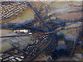
Castlecary Arches from the air
Formally known as Red Burn Viaduct, also known as Castlecary Viaduct, the Category B Listed structure http://portal.historicenvironment.scot/designation/LB10520 was built in 1842 to carry the main Glasgow to Edinburgh railway line over the Red Burn, a function which it still serves today. The M80 motorway now also makes use of two of the eight arches.
Image: © Thomas Nugent
Taken: 11 Dec 2017
0.12 miles