IMAGES TAKEN NEAR TO
Roadside, GLASGOW, G67 2SS
Introduction
This page details the photographs taken nearby to Roadside, G67 2SS by members of the Geograph project.
The Geograph project started in 2005 with the aim of publishing, organising and preserving representative images for every square kilometre of Great Britain, Ireland and the Isle of Man.

There are currently over 7.5m images from over14,400 individuals and you can help contribute to the project by visiting https://www.geograph.org.uk
Image Map
Images are licensed for reuse under creativecommons.org/licenses/by-sa/2.0
Notes
- Clicking on the map will re-center to the selected point.
- The higher the marker number, the further away the image location is from the centre of the postcode.
Image Listing (48 Images Found)
Images are licensed for reuse under creativecommons.org/licenses/by-sa/2.0
Image
Details
Distance
1

Roadside, Cumbernauld Village
Photo taken circa 1983
Image: © coughlan
Taken: Unknown
0.03 miles
2
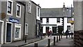
The Village
The Dunbartonshire village of Cumbernauld was situated on the junction of the A73 and A80, but otherwise in a rural setting. It is now an old bit lost just off the M80 motorway deep inside the large new town which has taken its name.
Image: © Richard Webb
Taken: 14 Oct 2011
0.10 miles
3

The Wynd, Cumbernauld
Older houses and buildings in The Village. All new towns have older communities hidden within them.
Image: © Richard Webb
Taken: 14 Oct 2011
0.10 miles
4
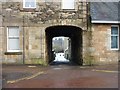
Archwayed Entrance, The Wynd
Archwayed entrance to rear courtyard.
The date on the centre stone is 1832.
Image: © Texas Radio and The Big Beat
Taken: 4 Feb 2010
0.10 miles
5

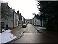
The Wynd (looking north)
The bell tower on the left is that of the United Free Kirk.
(Built as Burgher Meeting House 1743, re-built 1825 became Village Hall).
Image: © Texas Radio and The Big Beat
Taken: 4 Feb 2010
0.10 miles
6
The Wynd (looking south)
Image: © Texas Radio and The Big Beat
Taken: 4 Feb 2010
0.11 miles
7

Tunnel Vision
Tunnel under the A80 to Cumbernauld Village
Image: © Chris Upson
Taken: 19 Aug 2006
0.11 miles
8
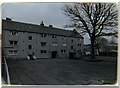
Burngreen Terrace, Cumbernauld Village
Photo taken circa 1983
Image: © coughlan
Taken: Unknown
0.11 miles
9
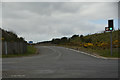
North Lanarkshire : The M80 Motorway - Junction 6
Heading up towards the M80 Motorway from the A8011.
Image: © Lewis Clarke
Taken: 25 Apr 2016
0.11 miles
10

A80 by Mainhead farm
One of Scotland's most hectic roads linking much of northern and eastern Scotland with the Glasgow/Lanarkshire conurbation and linking with the M74 south to England. Just beyond the road is the New Town of Cumbernauld. Mainhead farm is now a garden centre.
Image: © Jim Bain
Taken: 26 Feb 2006
0.11 miles