IMAGES TAKEN NEAR TO
Kincaidfield, GLASGOW, G66 8ER
Introduction
This page details the photographs taken nearby to Kincaidfield, G66 8ER by members of the Geograph project.
The Geograph project started in 2005 with the aim of publishing, organising and preserving representative images for every square kilometre of Great Britain, Ireland and the Isle of Man.

There are currently over 7.5m images from over14,400 individuals and you can help contribute to the project by visiting https://www.geograph.org.uk
Image Map
Images are licensed for reuse under creativecommons.org/licenses/by-sa/2.0
Notes
- Clicking on the map will re-center to the selected point.
- The higher the marker number, the further away the image location is from the centre of the postcode.
Image Listing (18 Images Found)
Images are licensed for reuse under creativecommons.org/licenses/by-sa/2.0
Image
Details
Distance
1
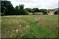
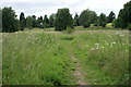
Footpath through the meadow
The meadow is situated between the old railway line and Birdston Road. The houses are on Kincaid Field.
Image: © Richard Sutcliffe
Taken: 14 Jul 2019
0.07 miles
2
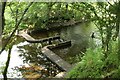
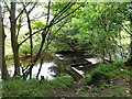
Weir on the Glazert Water
Just downstream from SEPA's monitoring station. For a similar view 9 years previously, see [https://www.geograph.org.uk/photo/2032721].
Image: © Richard Sutcliffe
Taken: 14 Jul 2019
0.07 miles
3
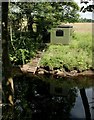
SEPA monitoring station, Glazert Water
One of the two river gauging stations on the Glazert Water. It seems to consist of a small square building which has steps leading down to the water. A wire runs across the river from this building to the other bank, and can just be seen on the left side of the photograph. This appears to be some kind of pulley system, presumably for transporting equipment from one side to the other. Immediately dwnstream of here is some sort of weir [https://www.geograph.org.uk/photo/6212909].
Image: © Richard Sutcliffe
Taken: 14 Jul 2019
0.07 miles
5
Footpath through the meadow
The meadow is situated between the old railway line and Birdston Road.
Image: © Richard Sutcliffe
Taken: 14 Jul 2019
0.11 miles
6
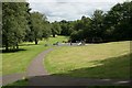
Glazert Water, Milton of Campsie
Just downstream of the SEPA monitoring station. I hestitate to name this structure.
Image: © Robert Murray
Taken: 25 Aug 2010
0.14 miles
8
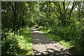
Strathkelvin Railway Path
The path along the old railway line runs from Gartcosh to Strathblane. This section is part of the former Campsie Branch (Edinburgh and Glasgow Railway) which opened in 1848 and finally closed in 1966.
Image: © Richard Sutcliffe
Taken: 14 Jul 2019
0.16 miles
9
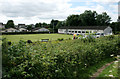
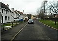
Beechtree Terrace, Milton of Campsie
Image: © Richard Sutcliffe
Taken: 14 Jul 2019
0.16 miles
10
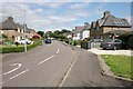
Birdston Road
The houses in this section of Birdston Road are set back from the main road itself.
Image: © Richard Sutcliffe
Taken: 25 Feb 2022
0.17 miles