IMAGES TAKEN NEAR TO
Glazert Park Drive, GLASGOW, G66 7EY
Introduction
This page details the photographs taken nearby to Glazert Park Drive, G66 7EY by members of the Geograph project.
The Geograph project started in 2005 with the aim of publishing, organising and preserving representative images for every square kilometre of Great Britain, Ireland and the Isle of Man.

There are currently over 7.5m images from over14,400 individuals and you can help contribute to the project by visiting https://www.geograph.org.uk
Image Map
Images are licensed for reuse under creativecommons.org/licenses/by-sa/2.0
Notes
- Clicking on the map will re-center to the selected point.
- The higher the marker number, the further away the image location is from the centre of the postcode.
Image Listing (37 Images Found)
Images are licensed for reuse under creativecommons.org/licenses/by-sa/2.0
Image
Details
Distance
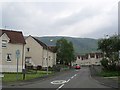
1
Milton Road (A891) in Lennoxtown
Looking north-westward.
Image: © Peter Wood
Taken: 5 Oct 2017
0.03 miles
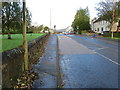
3
Holyknowe Road
View up a residential street towards the Campsie Fell escarpment.
Image: © Richard Webb
Taken: 1 Jun 2012
0.06 miles
4
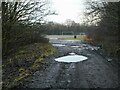
Track to Ferguson Park
The track leads from Chestnut Walk to the Ferguson Park Recreation Ground in the distance. The pot holes are full of water after a recent rain shower.
Image: © Richard Sutcliffe
Taken: 22 Dec 2020
0.07 miles
5
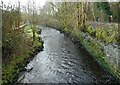
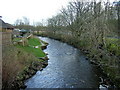
Glazert Water
Seen from the bridge carrying Chestnut Walk over the river. On the right, some walkers are following part of the Strathkelvin Railway Path, which follows the line of the former Blane Valley Railway.
The image replicates the first submitted for this square in 2006 Image
Image: © Richard Sutcliffe
Taken: 22 Dec 2020
0.07 miles
7
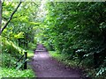
Lennoxtown, path to Milton of Campsie
Follows the old track of the LNER railway which connected Kirkintilloch with the near north.
Image: © Robert Murray
Taken: 5 Sep 2011
0.09 miles
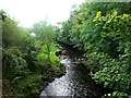
8
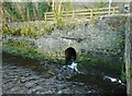
Culvert under the old railway line
Water from a drainage ditch on the other side of the former Blane Valley Railway line joins the Glazert Water.
Image: © Richard Sutcliffe
Taken: 22 Dec 2020
0.09 miles
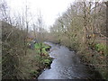
9
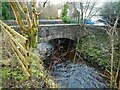
Bridge over the Glazert Water
Chestnut Walk crosses the river.
Image: © Richard Sutcliffe
Taken: 22 Dec 2020
0.09 miles