IMAGES TAKEN NEAR TO
Milton Road, GLASGOW, G66 7DJ
Introduction
This page details the photographs taken nearby to Milton Road, G66 7DJ by members of the Geograph project.
The Geograph project started in 2005 with the aim of publishing, organising and preserving representative images for every square kilometre of Great Britain, Ireland and the Isle of Man.

There are currently over 7.5m images from over14,400 individuals and you can help contribute to the project by visiting https://www.geograph.org.uk
Image Map
Images are licensed for reuse under creativecommons.org/licenses/by-sa/2.0
Notes
- Clicking on the map will re-center to the selected point.
- The higher the marker number, the further away the image location is from the centre of the postcode.
Image Listing (43 Images Found)
Images are licensed for reuse under creativecommons.org/licenses/by-sa/2.0
Image
Details
Distance
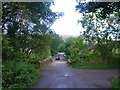
3
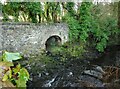
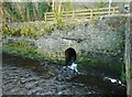
Culvert under the old railway line
Looking at old maps, the large culvert just to the west of the Chestnut Walk bridge over the Glazert Water appears to have been to allow water from an old lade to enter the river. The lade led to the Campsie Alum Works just south of the railway.
Image: © Richard Sutcliffe
Taken: 22 Dec 2020
0.06 miles
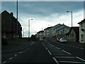
4
John Muir Way
Follows the course of the former railway to Aberfoyle. The line here was opened in 1848 and closed to passengers in 1951. Goods services ceased in 1966.
Image: © Jonathan Thacker
Taken: 22 Nov 2018
0.06 miles
5
Culvert under the old railway line
Water from a drainage ditch on the other side of the former Blane Valley Railway line joins the Glazert Water.
Image: © Richard Sutcliffe
Taken: 22 Dec 2020
0.07 miles
6
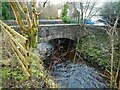
Bridge over the Glazert Water
Chestnut Walk crosses the river.
Image: © Richard Sutcliffe
Taken: 22 Dec 2020
0.07 miles
8
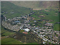
Lennoxtown from the air
At the foot of the Campsie Fells, the Crow Road can be seen ascending the hill in the top left corner.
Image: © Thomas Nugent
Taken: 7 Apr 2016
0.07 miles
9
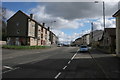
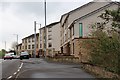
Main Street, Lennoxtown
Looking south east.
Image: © Richard Sutcliffe
Taken: 28 Mar 2016
0.07 miles
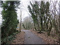
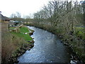
10
Lennoxtown, road, paths and bridge
The path from Strathblane to Kirkintilloch crosses the scene and the bridge over the Glazert leads into the town via Chestnut Walk seen in the distance.
Image: © Robert Murray
Taken: 5 Sep 2011
0.07 miles