IMAGES TAKEN NEAR TO
Kirkintilloch, GLASGOW, G66 5LB
Introduction
This page details the photographs taken nearby to G66 5LB by members of the Geograph project.
The Geograph project started in 2005 with the aim of publishing, organising and preserving representative images for every square kilometre of Great Britain, Ireland and the Isle of Man.

There are currently over 7.5m images from over14,400 individuals and you can help contribute to the project by visiting https://www.geograph.org.uk
Image Map
Images are licensed for reuse under creativecommons.org/licenses/by-sa/2.0
Notes
- Clicking on the map will re-center to the selected point.
- The higher the marker number, the further away the image location is from the centre of the postcode.
Image Listing (5 Images Found)
Images are licensed for reuse under creativecommons.org/licenses/by-sa/2.0
Image
Details
Distance
1
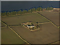
Parkhillhead Farm from the air
Traces of green are just visible in the neatly ploughed fields. Gadloch is in the background.
Image: © Thomas Nugent
Taken: 9 Feb 2018
0.01 miles
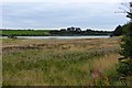
2
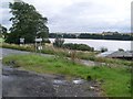
Gadloch
Small loch between Bishopbriggs and Kirkintilloch.
Image: © G Laird
Taken: 25 Dec 2013
0.18 miles
3
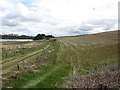
Road, south of the Gadloch
Leads to a car park (fishing?) and is wisely locked. Keep out signs, apart from being of dubious legality do not deter dumpers. Someone was struggling with the lock.
Image: © Richard Webb
Taken: 9 May 2012
0.20 miles
4
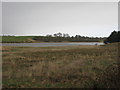
View to the Gadloch
The existence of this sheet of water would seem to be due to coal mining and resultant subsidence as it doesn't appear on Ordnance maps as recent as 1914.
Image: © Robert Murray
Taken: 3 Oct 2015
0.24 miles