IMAGES TAKEN NEAR TO
Alloway Grove, GLASGOW, G66 2RE
Introduction
This page details the photographs taken nearby to Alloway Grove, G66 2RE by members of the Geograph project.
The Geograph project started in 2005 with the aim of publishing, organising and preserving representative images for every square kilometre of Great Britain, Ireland and the Isle of Man.

There are currently over 7.5m images from over14,400 individuals and you can help contribute to the project by visiting https://www.geograph.org.uk
Image Map (Loading...)


Getting Data...Please wait
Leaflet Map data © OpenStreetMap
Images are licensed for reuse under creativecommons.org/licenses/by-sa/2.0
Notes
- Clicking on the map will re-center to the selected point.
- The higher the marker number, the further away the image location is from the centre of the postcode.
Image Listing (23 Images Found)
Images are licensed for reuse under creativecommons.org/licenses/by-sa/2.0
Image
Details
Distance
1
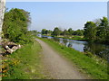
Inchbelly on the Forth & Clyde
This early summer view of the canal is notable because of the Antonine Wall, which runs along the right bank, and is eventually breached by the canal as the canal bends to the right and takes over the alignment of the canal for around 100 metres.
Image: © Raymond Okonski
Taken: 3 May 2007
0.11 miles
2
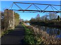
Pipe bridge over the Forth & Clyde Canal near Harestanes
Image: © Gordon Brown
Taken: 22 Nov 2015
0.11 miles
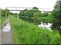
4
Bend in the canal
At this point the Forth and Clyde Canal crosses the line of the Antonine Wall.
Image: © Richard Sutcliffe
Taken: 23 Feb 2020
0.11 miles
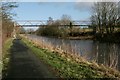
5
Pipe Bridge across the Forth and Clyde Canal
In the eastern outskirts of Kirkintilloch.
Image: © G Laird
Taken: 24 Jun 2012
0.13 miles
6
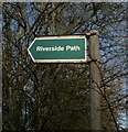
Sign for Riverside Path
The path leads from the A803, Kilsyth Road to the River Kelvin Image
Image: © Richard Sutcliffe
Taken: 23 Feb 2020
0.16 miles
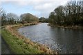
7
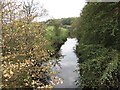
River Kelvin
Looking upstream from Inchbelly Bridge.
Image: © Richard Webb
Taken: 30 Sep 2011
0.16 miles
8
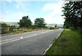
Inchbelly Bridge
The A803 crosses the River Kelvin.
Image: © Richard Sutcliffe
Taken: 31 Jul 2020
0.17 miles
9
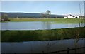
Flooded field
Following very heavy rain the previous day, the River Kelvin (in the foreground) broke its banks and flooded many fields in the area. Bridgend Farm is on the right.
Image: © Richard Sutcliffe
Taken: 23 Feb 2020
0.17 miles
10
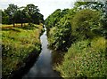
River Kelvin
Looking west from Inchbelly Bridge. The river has been straightened here in the past. Old maps show the original course of the Kelvin meandering here.
Image: © Richard Sutcliffe
Taken: 31 Jul 2020
0.17 miles