IMAGES TAKEN NEAR TO
Kelvinvale, GLASGOW, G66 1RB
Introduction
This page details the photographs taken nearby to Kelvinvale, G66 1RB by members of the Geograph project.
The Geograph project started in 2005 with the aim of publishing, organising and preserving representative images for every square kilometre of Great Britain, Ireland and the Isle of Man.

There are currently over 7.5m images from over14,400 individuals and you can help contribute to the project by visiting https://www.geograph.org.uk
Image Map
Images are licensed for reuse under creativecommons.org/licenses/by-sa/2.0
Notes
- Clicking on the map will re-center to the selected point.
- The higher the marker number, the further away the image location is from the centre of the postcode.
Image Listing (123 Images Found)
Images are licensed for reuse under creativecommons.org/licenses/by-sa/2.0
Image
Details
Distance
1
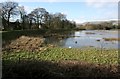
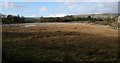
A bund doing its job
This area of grassland is part of the original floodplain of the River Kelvin, just out of sight behind the trees on the right. This bund was built several years ago to protect the properties behind it on the left. It is clearly doing its job as the grassland has flooded due to high water levels just after Storm Dennis.
Image: © Richard Sutcliffe
Taken: 23 Feb 2020
0.07 miles
2
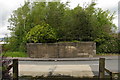
Campsie Branch Bridge, Kirkintilloch
Looking north this is all that remains of the original railway bridge that crossed the main Glasgow to Kilsyth road (A803). There is no evidence of Kirkintilloch Station - the Campsie View retirement home saw to that. From this point, the Strathkelvin Railway route provides a tranquil countryside path to Milton of Bampsie and Lennoxtown.
Image: © Raymond Okonski
Taken: 20 May 2007
0.07 miles
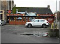
3
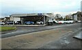
Car Dealership
Evans Halshaw, a Ford dealership on Kilsyth Road, Kirkintilloch.
Image: © Richard Sutcliffe
Taken: 16 Nov 2022
0.08 miles
4
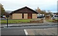
Funeral Directors
J & D Lawson, Funeral Directors on Kilsyth Road.
Image: © Richard Sutcliffe
Taken: 16 Nov 2022
0.08 miles
5
A bit of flood plain
This area of grassland is part of the original floodplain of the River Kelvin, just out of sight behind the trees. While adjacent areas have been built on and protected by bunds, this area is still able to flood when water levels are high, as has just happened after Storm Dennis.
Image: © Richard Sutcliffe
Taken: 23 Feb 2020
0.08 miles
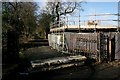
6

A reminder of the railway
A small part of the wall of the old railway bridge over Kilsyth Road. The bridge carried the Campsie Branch of the Edinburgh and Glasgow Railway, which ran from Lenzie to Lennoxtown. The line opened in 1848 and finally closed in 1966. Today a footpath runs along the old trackbed to Lennoxtown and then along the Strathblane Railway path.
Image: © Richard Sutcliffe
Taken: 16 Nov 2022
0.10 miles
7
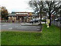
McDonald's, Kirkintilloch
At the corner of Milton Road and Kilsyth Road. Fast food drive-thru and delivery.
Image: © Richard Sutcliffe
Taken: 16 Nov 2022
0.11 miles
8
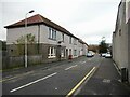
Crossgate, Kirkintilloch
Looking towards Kilsyth Road.
Image: © Richard Sutcliffe
Taken: 16 Nov 2022
0.11 miles
9
Former driveway to Broomhill
This was originally the drive to a large villa called Broomhill (later Broomhill Hospital). The hospital complex closed in 1995. Behind the scaffolding, barriers and screens on the right is the former lodge to the house. It dates from the earlier to mid 19th century. The lodge, boundary wall, gatepiers and gates are Category C listed http://portal.historicenvironment.scot/designation/LB49875.
On the Buildings at Risk Register https://www.buildingsatrisk.org.uk/details/906940, Listed Building Consent was sought in July 2019, and the building has subsequently been partly demolished as part of a development by Cala Homes. It remains to be seen how sympathetically it is rebuilt.
Image: © Richard Sutcliffe
Taken: 23 Feb 2020
0.11 miles
10
Nico's
Tandoori takeaway attached to the Indian Cottage restaurant.
Image: © Richard Sutcliffe
Taken: 16 Nov 2022
0.12 miles