IMAGES TAKEN NEAR TO
Glenview, GLASGOW, G66 1PG
Introduction
This page details the photographs taken nearby to Glenview, G66 1PG by members of the Geograph project.
The Geograph project started in 2005 with the aim of publishing, organising and preserving representative images for every square kilometre of Great Britain, Ireland and the Isle of Man.

There are currently over 7.5m images from over14,400 individuals and you can help contribute to the project by visiting https://www.geograph.org.uk
Image Map
Images are licensed for reuse under creativecommons.org/licenses/by-sa/2.0
Notes
- Clicking on the map will re-center to the selected point.
- The higher the marker number, the further away the image location is from the centre of the postcode.
Image Listing (304 Images Found)
Images are licensed for reuse under creativecommons.org/licenses/by-sa/2.0
Image
Details
Distance
1
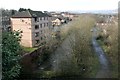
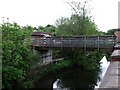
View from the Unique Bridge
Looking from the towpath of the Luggie Aqueduct or 'Unique Bridge' on the Forth and Clyde Canal. The bridge crosses both the Luggie Water and the route of the former Campsie Branch Railway (now a cycle path) Image On the left the modern flats occupy the site of the former Lion Foundry.
Image: © Richard Sutcliffe
Taken: 23 Feb 2020
0.04 miles
2
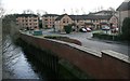
Houses beside the Luggie Water
These recently built houses are on the site of the former Lion Foundry, which operated here from 1880 until 1884. See Canmore https://canmore.org.uk/site/216122/kirkintilloch-eastside-lion-foundry to see images of the foundry when still operational.
Image: © Richard Sutcliffe
Taken: 15 Jan 2020
0.05 miles
4
The Forth & Clyde Canal crosses "The Unique Bridge"
The canal aqueduct flies over the course of a disused railway, which bridges over the Luggie Water.
Image: © Gordon Brown
Taken: 22 Nov 2015
0.05 miles
5
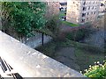
Footbridge over the Luggie, Kirkintilloch
Situated in a built up area east of the town centre.
Image: © Robert Murray
Taken: 29 May 2010
0.05 miles
6
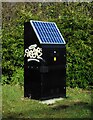
Solar-powered box
There is no indication as to what the function of this box might be. It is set beside the tow path of the canal.
Image: © Richard Sutcliffe
Taken: 17 Feb 2022
0.06 miles
7
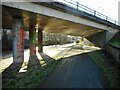
Road bridge over the canal
The Kirkintilloch Bypass (A806) crosses the Forth and Clyde Canal. The bridge at Townhead is just visible in the distance.
Image: © Richard Sutcliffe
Taken: 17 Feb 2022
0.07 miles
8
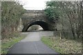
Luggie Aqueduct and bridge from the northwest
The aqueduct was built by John Smeaton between 1768 and 1775 to carry the Forth & Clyde Canal over the Luggie Water. The river was later culverted and a bridge built over the river below the aqueduct for the Campsie Branch railway, which opened in 1848, to cross over the river and under the canal at the same spot. The railway closed in 1966, and the bridge is now part of the walkway beside (and over) the Luggie Water.
The structure is Category A listed http://portal.historicenvironment.scot/designation/LB36655, https://canmore.org.uk/site/168444/forth-and-clyde-canal-kirkintilloch-luggie-water-aqueduct.
Image: © Richard Sutcliffe
Taken: 15 Jan 2020
0.07 miles
9
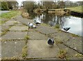
Pigeons beside the canal
Some feral pigeons beside the Forth and Clyde Canal.
Image: © Richard Sutcliffe
Taken: 27 Feb 2023
0.07 miles
10
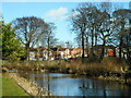
Forth & Clyde Canal
Looking across the canal towards houses on Waverley Park. A pair of mallard swim along the canal towards the Hillhead Basin.
Image: © Richard Sutcliffe
Taken: 17 Feb 2022
0.07 miles