IMAGES TAKEN NEAR TO
Gavell Road, GLASGOW, G65 9NG
Introduction
This page details the photographs taken nearby to Gavell Road, G65 9NG by members of the Geograph project.
The Geograph project started in 2005 with the aim of publishing, organising and preserving representative images for every square kilometre of Great Britain, Ireland and the Isle of Man.

There are currently over 7.5m images from over14,400 individuals and you can help contribute to the project by visiting https://www.geograph.org.uk
Image Map
Images are licensed for reuse under creativecommons.org/licenses/by-sa/2.0
Notes
- Clicking on the map will re-center to the selected point.
- The higher the marker number, the further away the image location is from the centre of the postcode.
Image Listing (10 Images Found)
Images are licensed for reuse under creativecommons.org/licenses/by-sa/2.0
Image
Details
Distance
1
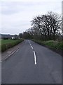
Queenzieburn to Twechar Road
This road runs across the Kelvin flood plain.
Queenzieburn is pronounced 'Queenieburn' as local patois dictates the dropping of a Z in placenames.
Image: © Robert Murray
Taken: 24 Apr 2010
0.03 miles
2
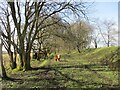
Shetland pony on a dismantled railway line
This was once part of the course of the Kelvin Valley railway line.
Image: © Alan O'Dowd
Taken: 27 Mar 2021
0.05 miles
3
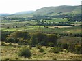
The Kelvin Valley
Seen from the top of Bar Hill. The Campsie Fells are in the background.
Image: © Richard Sutcliffe
Taken: 18 Sep 2020
0.06 miles
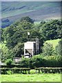
4
Bridge over the Queenzie Burn at Gavell
Old bridge of the Kelvin Valley Railway still in place across the burn. Note the wooden supports for removed rails.
Image: © Robert Murray
Taken: 25 Aug 2010
0.06 miles
5
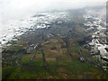
Queenzieburn and Kilsyth from the air
The line of the former Kelvin Valley Railway can be seen running vertically in the foreground.
Image: © Thomas Nugent
Taken: 24 Feb 2017
0.10 miles
6
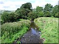
The Queenzie Burn
The final name of this burn which started out being called the Hailstanes Burn up in the hills above the village of Queenzieburn.
Image: © Robert Murray
Taken: 25 Aug 2010
0.12 miles
7
Line of Kelvin Valley Railway
Built on a raised embankment across the flood plain, here, west of the old Gavell Station.
Image: © Robert Murray
Taken: 25 Aug 2010
0.16 miles
8
Old sewage treatment works, near Queenzieburn
And that's an American Confederate flag flying.
Image: © Robert Murray
Taken: 25 Aug 2010
0.18 miles
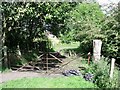
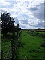
9
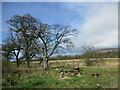
Trees on the boundary of farmland and open ground, Gavell
Image: © Alan O'Dowd
Taken: 27 Mar 2021
0.20 miles
10
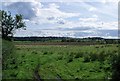
Across the Kelvin flood plain
Looking towards Twechar.
Image: © Robert Murray
Taken: 25 Aug 2010
0.25 miles