IMAGES TAKEN NEAR TO
Old Mailings, GLASGOW, G65 0QU
Introduction
This page details the photographs taken nearby to Old Mailings, G65 0QU by members of the Geograph project.
The Geograph project started in 2005 with the aim of publishing, organising and preserving representative images for every square kilometre of Great Britain, Ireland and the Isle of Man.

There are currently over 7.5m images from over14,400 individuals and you can help contribute to the project by visiting https://www.geograph.org.uk
Image Map
Images are licensed for reuse under creativecommons.org/licenses/by-sa/2.0
Notes
- Clicking on the map will re-center to the selected point.
- The higher the marker number, the further away the image location is from the centre of the postcode.
Image Listing (39 Images Found)
Images are licensed for reuse under creativecommons.org/licenses/by-sa/2.0
Image
Details
Distance
1
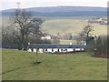
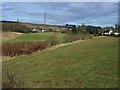
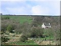
Mailings
N.E. of Banton. A new house which was formerly known as Banton Mains sits on the rise in the distance while 50,000 Sitka Spruce cast a shadow from the high braes.
Image: © Robert Murray
Taken: 18 Feb 2010
0.00 miles
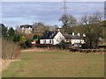
2
Cottages at Mailings
These cottages appear on 1860's map
Image: © Jim Smillie
Taken: 7 Mar 2023
0.01 miles
3
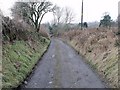
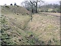
Sunken lone
Lone is an old Scots word for lane. We have sunken lones/lanes on hillsides because they were dug out to reduce the gradient and therefore assist the passage of carts on the upward journey.
Image: © Robert Murray
Taken: 18 Feb 2010
0.04 miles
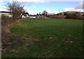
4
Mailings
A hamlet of one house and a row of ploughman's cottages N.E. of Banton. Medowside farmhouse sits on the horizon.
Image: © Robert Murray
Taken: 13 Feb 2010
0.04 miles
5
Old course of mill lade
As it approaches the north end of Mailings. See http://www.geograph.org.uk/photo/1715737 for full description
Image: © Robert Murray
Taken: 18 Feb 2010
0.07 miles
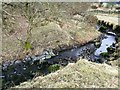
6
Line of Craigdouffie Burn
It flows south-west from Mailings towards Banton.
Image: © Robert Murray
Taken: 13 Feb 2010
0.09 miles
7
Craigdouffie Burn, old lade to Auchincloch
As the title suggests this lade took water from the Craigdouffie Burn to a corn mill at Auchincloch almost mile to the south east astride the A803 Kilsyth - Banknock road.
Filled in circa.1975 according to a long time local resident of Mailings this lade was 3/4 of a mile (1.25km) long between the weir and where it joined the Auchincloch burn.
Image: © Robert Murray
Taken: 18 Feb 2010
0.11 miles
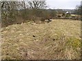
8
Craigdouffie Burn, remains of weir
This is where the weir was situated that raised the water level to the take off mill lade.
Image: © Robert Murray
Taken: 18 Feb 2010
0.12 miles
9
Binniemyre
Small farm, and also once a colliery, near Banton.
Image: © Richard Webb
Taken: 7 Apr 2005
0.12 miles
10
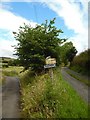
Track junction east of Banton village
Signposts for Meadowside Farm and Binniemyre.
Image: © Stephen Sweeney
Taken: 4 Aug 2016
0.13 miles