IMAGES TAKEN NEAR TO
Kelvinhead, GLASGOW, G65 0QJ
Introduction
This page details the photographs taken nearby to Kelvinhead, G65 0QJ by members of the Geograph project.
The Geograph project started in 2005 with the aim of publishing, organising and preserving representative images for every square kilometre of Great Britain, Ireland and the Isle of Man.

There are currently over 7.5m images from over14,400 individuals and you can help contribute to the project by visiting https://www.geograph.org.uk
Image Map
Images are licensed for reuse under creativecommons.org/licenses/by-sa/2.0
Notes
- Clicking on the map will re-center to the selected point.
- The higher the marker number, the further away the image location is from the centre of the postcode.
Image Listing (36 Images Found)
Images are licensed for reuse under creativecommons.org/licenses/by-sa/2.0
Image
Details
Distance
1
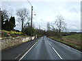
Kelvinhead Road
Heading south east towards the A803.
Image: © JThomas
Taken: 30 Mar 2017
0.03 miles
2
Kelvin Water
Flowing from source south of Banton Kirk.
Image: © Robert Murray
Taken: 30 Jan 2010
0.04 miles
3
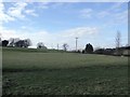
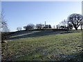
Ruchill Fields
Looking north with the Kilsyth Hills on the horizon.
Image: © Robert Murray
Taken: 13 Feb 2010
0.07 miles
4
Farmland, Kelvinhead
The signifigance of the name Kelvinhead passed me by when I was there. This is not just the upper reaches of one of Glasgow's famous rivers, but the east - west watershed of Scotland.
Strictly speaking this field is just west of the watershed, but I expect Dave Hewitt and those who followed him doing the epic walk would have used the road to Banton beside this field.
Image: © Richard Webb
Taken: 30 Sep 2011
0.07 miles
5
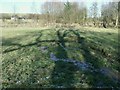
Spring in the field
This is another part of the source of the River Kelvin jigsaw. Situated in a field behind the hamlet of Kelvinhead next to the road to Banton this mud spring bubbles from beneath and flows into the trees where the exposed burn flows in a gully.
This spring escapes from a culvert under the field. This culvert was laid prior to 1899 over which the tramway ran from Kelvin Jetty on the Forth & Clyde Canal through this field for a short distance and via the left side of Banton Road - following the line of the burn - and then past [Low] Banton to the pits near Binniemyre. O.S. Second Edition of 1899 Stirlingshire Sheet XXIX. N.W. refers.
The true source of the Kelvin is further up the Banton Road, south of Banton Kirk.
See www.geograph.org.uk/photo/1686956 and www.geograph.org.uk/photo/1702700
Image: © Robert Murray
Taken: 30 Jan 2010
0.10 miles
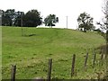
6
The Lands of Ruchill
Presumably this is the Ruchill. The horizontal line across the hill is the old track of the Kilsyth to bonnybridge railway.
Image: © Robert Murray
Taken: 30 Jan 2010
0.10 miles
7
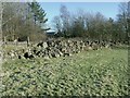
Pile of boulders
Adjacent to the Kelvinhead - Banton road. This feature is not unusual in this district.
Image: © Robert Murray
Taken: 30 Jan 2010
0.11 miles
8
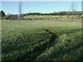
Leaky old culvert
Beneath which flows the Kelvin. Following a straight imaginary line would take you to the field gate about 100m away, this was the line of the tramway and hence the reason the young Kelvin was put into a culvert. See www.geograph.org.uk/photo/1687020
Image: © Robert Murray
Taken: 30 Jan 2010
0.11 miles
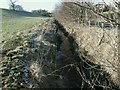
9
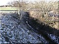
Headwaters of the Kelvin
Making a decent cut through the land even though it has just surfaced.
Image: © Robert Murray
Taken: 30 Jan 2010
0.11 miles
10
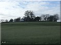
Ruchill fields
The farm of the same name sits atop the hill.
Image: © Robert Murray
Taken: 13 Feb 2010
0.11 miles