IMAGES TAKEN NEAR TO
Kilsyth, GLASGOW, G65 0QE
Introduction
This page details the photographs taken nearby to G65 0QE by members of the Geograph project.
The Geograph project started in 2005 with the aim of publishing, organising and preserving representative images for every square kilometre of Great Britain, Ireland and the Isle of Man.

There are currently over 7.5m images from over14,400 individuals and you can help contribute to the project by visiting https://www.geograph.org.uk
Image Map
Images are licensed for reuse under creativecommons.org/licenses/by-sa/2.0
Notes
- Clicking on the map will re-center to the selected point.
- The higher the marker number, the further away the image location is from the centre of the postcode.
Image Listing (54 Images Found)
Images are licensed for reuse under creativecommons.org/licenses/by-sa/2.0
Image
Details
Distance
1
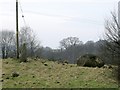
Boulders and Standing Stones
At Townhead Farm. It seems a random affair but there is one totally upright stone.
The RCAHMS possibly records this > www.canmore.rcahms.gov.uk/en/site/45891/details/townhead/
Image: © Robert Murray
Taken: 21 Jan 2010
0.02 miles
2
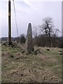
Old and the New
Or the old and older? Two very upright objects one natural and one of more technological origin.
Image: © Robert Murray
Taken: 21 Jan 2010
0.02 miles
3
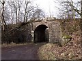
Railway Bridge at Townhead Farm
The Kilsyth to Bonnybridge line. Built by the Kilsyth & Bonnybridge Railway which was taken over jointly by the North British Railway and Caledonian Railways in 1908. In 1921 those in turn where taken over by the LNER and LMS railway companies.
Image: © Robert Murray
Taken: 21 Jan 2010
0.04 miles
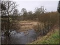
4
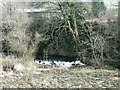
Shawend Burn at Townhead Farm
The weir that diverted a channel which split into two lades for Craigmarloch mill downstream.
Image: © Robert Murray
Taken: 21 Jan 2010
0.04 miles
5
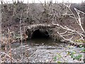
Shawend Burn
Going under this high banking of the old Kilsyth to Bonnybridge railway line.
Image: © Robert Murray
Taken: 21 Jan 2010
0.06 miles
6
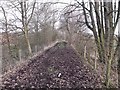
Kilsyth to Bonnybridge Railway line
This line opened on 2 July 1888 by a private company. It was linked to the North British Railway at Kilsyth in the west, and to the Caldeonian Railway at Bonny Water Junction in the east. Passenger services ended 1 February 1935. The line was abandoned in stages as pits closed and the last section from Kilsyth to Banknock finally closed to traffic on 4 May 1964.
Image: © Robert Murray
Taken: 21 Jan 2010
0.06 miles
7
Overflow Channel from reservoir
This is where the overflow from www.geograph.org.uk/photo/1672855 would come to before joining the Shawend Burn.
Image: © Robert Murray
Taken: 21 Jan 2010
0.07 miles
9
Townhead Reservoir, overflow channel
Should the sluice at the weir www.geograph.org.uk/photo/1672834 malfunction or is unable to cope then overflow will take this channel and over the edge down to the Shawend Burn.
Image: © Robert Murray
Taken: 21 Jan 2010
0.09 miles
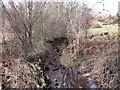
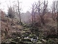
10
Shawend Burn
After leaving Townhead Reservoir. At this time the burn was in heavy spate due to snow melt in the hills and looked more like a river.
Image: © Robert Murray
Taken: 21 Jan 2010
0.09 miles