IMAGES TAKEN NEAR TO
Killearn, GLASGOW, G63 9LQ
Introduction
This page details the photographs taken nearby to G63 9LQ by members of the Geograph project.
The Geograph project started in 2005 with the aim of publishing, organising and preserving representative images for every square kilometre of Great Britain, Ireland and the Isle of Man.

There are currently over 7.5m images from over14,400 individuals and you can help contribute to the project by visiting https://www.geograph.org.uk
Image Map
Images are licensed for reuse under creativecommons.org/licenses/by-sa/2.0
Notes
- Clicking on the map will re-center to the selected point.
- The higher the marker number, the further away the image location is from the centre of the postcode.
Image Listing (33 Images Found)
Images are licensed for reuse under creativecommons.org/licenses/by-sa/2.0
Image
Details
Distance
1
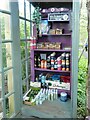
Inside the Honesty Box
Situated beside the West Highland Way, the honesty box Image is provided by the adjacent 'turnip the beet', a 'World Cuisine Deli & Zero Waste Shop'. It contains a small selection of drinks and snacks, plus most important of all, midge repellant and midge-proof headnets.
Image: © Richard Sutcliffe
Taken: 11 May 2023
0.00 miles
2
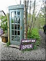
Honesty Box
Situated beside the West Highland Way, the honesty box is provided by the adjacent 'turnip the beet', a 'World Cuisine Deli & Zero Waste Shop'. It contains a small selection of drinks and snacks, plus most important of all, midge repellant and midge-proof headnets.
Image: © Richard Sutcliffe
Taken: 11 May 2023
0.00 miles
3
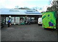
Turnip the beet
A 'World Cuisine Deli & Zero Waste Shop', beside the West Highland Way.
Image: © Richard Sutcliffe
Taken: 11 May 2023
0.01 miles
4

Old brick buildings
It is not clear what these small buildings are. They were probably associated with either the former railway line, which ran just behind them, or the sawmill that used to be here.
Image: © Richard Sutcliffe
Taken: 11 May 2023
0.01 miles
5
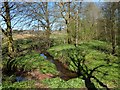
Confluence of burns
See Image, where this area appears on the right. The present picture shows what appears to be a single burn with a sharp turn in it, but it is a meeting of two burns: the one entering from the left is the Kirkhouse Burn; the other, which seems to be unnamed, runs near the edge of a strip of woodland. The burns meet here, and their combined waters flow beneath the track. These details are depicted on the 1:25000 map.
Image: © Lairich Rig
Taken: 18 Apr 2014
0.03 miles
6
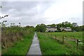
The West Highland Way approaching Lettreburn
Still following what is now becoming a slightly monotonous railway track - though it provides the advantage of a relatively dry path compared with the neighbouring sodden fields.
Image: © Tim Heaton
Taken: 12 May 2014
0.04 miles
7
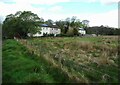
Lettreburn
These houses are in Lettreburn, which is on the south-western fringes of Killearn. The picture was taken from the West Highland Way.
The same buildings can be seen in the distance, to the right of the path, in Image
Image: © Lairich Rig
Taken: 30 Jun 2011
0.04 miles
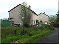
8
Lettreburn
Houses at the end of Drumbeg Loan. Seen from the West Highland Way.
Image: © Richard Sutcliffe
Taken: 11 May 2023
0.04 miles
9
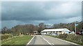
Campbells Controls unit on A81
On sharp bend north of Dumgoyne
Image: © John Firth
Taken: 15 Apr 2015
0.04 miles
10
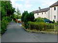
Houses on Drumbeg Loan
At the west side of the road, near Killearn.
Image: © Stephen Sweeney
Taken: 30 Jun 2013
0.05 miles