IMAGES TAKEN NEAR TO
Craigfern Drive, GLASGOW, G63 9DP
Introduction
This page details the photographs taken nearby to Craigfern Drive, G63 9DP by members of the Geograph project.
The Geograph project started in 2005 with the aim of publishing, organising and preserving representative images for every square kilometre of Great Britain, Ireland and the Isle of Man.

There are currently over 7.5m images from over14,400 individuals and you can help contribute to the project by visiting https://www.geograph.org.uk
Image Map
Images are licensed for reuse under creativecommons.org/licenses/by-sa/2.0
Notes
- Clicking on the map will re-center to the selected point.
- The higher the marker number, the further away the image location is from the centre of the postcode.
Image Listing (85 Images Found)
Images are licensed for reuse under creativecommons.org/licenses/by-sa/2.0
Image
Details
Distance
1
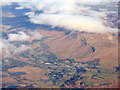
Strathblane and the Strathblane Hills escarpment
A view looking north from above Glasgow. The two bodies of water at the lower centre are the Deil's Craig Dam and Loch Ardinning.
Image: © M J Richardson
Taken: 9 Feb 2015
0.06 miles
2
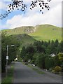
Kirkhouse Road, Netherton
Under some typical Campsie crags on Binnen.
Image: © Richard Webb
Taken: 1 Jun 2012
0.09 miles
3
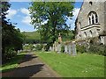
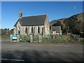
Strathblane Cemetery
The cemetery is next to the kirkyard of Image, and communicates with it by means of steps. See Image for a view in the opposite direction.
Image: © Lairich Rig
Taken: 20 Jun 2014
0.10 miles
6
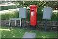
Pillar box and grey postal boxes, Kirkhouse Road
Postbox number G63 1360.
Image: © Richard Sutcliffe
Taken: 8 Jul 2017
0.11 miles

10
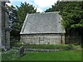
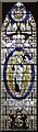
Strathblane Parish Kirkyard: Duntreath Burying Place
Large-scale OS mapping shows this building and its enclosing fence just to the north-east of Image It is a mausoleum for the Edmonstones of Duntreath.
Image: © Lairich Rig
Taken: 20 Jun 2014
0.11 miles