IMAGES TAKEN NEAR TO
Southburn Road, GLASGOW, G63 9DB
Introduction
This page details the photographs taken nearby to Southburn Road, G63 9DB by members of the Geograph project.
The Geograph project started in 2005 with the aim of publishing, organising and preserving representative images for every square kilometre of Great Britain, Ireland and the Isle of Man.

There are currently over 7.5m images from over14,400 individuals and you can help contribute to the project by visiting https://www.geograph.org.uk
Image Map
Images are licensed for reuse under creativecommons.org/licenses/by-sa/2.0
Notes
- Clicking on the map will re-center to the selected point.
- The higher the marker number, the further away the image location is from the centre of the postcode.
Image Listing (92 Images Found)
Images are licensed for reuse under creativecommons.org/licenses/by-sa/2.0
Image
Details
Distance
1
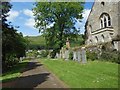
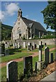
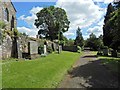
Strathblane Cemetery
The cemetery is next to the kirkyard of Image, and communicates with it by means of steps. See Image for a view in the opposite direction.
Image: © Lairich Rig
Taken: 20 Jun 2014
0.05 miles
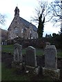
5
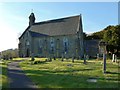
Strathblane Parish Church
For views of the kirkyard, see Image and Image; the second of those links includes the "standing stone" that is marked on the 1:25000 map; see Image for a closer look, and for more information. The tall memorial that can be seen on the right, close to the church, in the present picture is the Image
By 1799, the previous church on this site (dating from the early eighteenth century, and itself the successor of an earlier church) was in very poor condition. In that year, the heritors recognised the need for a new building, but financial considerations forced them to defer the necessary work for a few years. Three years later, they unanimously resolved to build a new church.
The architect was John Brash, the mason was a Mr Ramsay, and the woodworkers were John Craig and James Mason, both local men. The stone for the church was taken from the Kirklands Quarry (Image?). The building was ready by the start of 1804.
There were later improvements and alterations, most notably those that were initiated in 1870 by Sir Archibald Edmonstone of Duntreath (d.1871), and completed by his brother and successor, Sir William.
Image: © Lairich Rig
Taken: 18 Apr 2014
0.06 miles
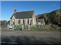
6
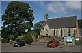
Strathblane Parish Church
The church sits beside the A891.
Image: © Richard Sutcliffe
Taken: 5 Sep 2015
0.06 miles
7
Strathblane Parish Church and churchyard
Category B listed church, built in 1803.
Image: © Richard Sutcliffe
Taken: 8 Jul 2017
0.06 miles
8
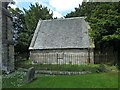
Strathblane Parish Kirkyard: Duntreath Burying Place
Large-scale OS mapping shows this building and its enclosing fence just to the north-east of Image It is a mausoleum for the Edmonstones of Duntreath.
Image: © Lairich Rig
Taken: 20 Jun 2014
0.06 miles
9
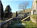
Strathblane Cemetery
The cemetery is next to the kirkyard of Image, and communicates with it by means of steps. See Image for a view in the opposite direction.
Image: © Lairich Rig
Taken: 20 Jun 2014
0.06 miles
10
Strathblane Parish Kirkyard
This enclosure is to the south-west of the church (for which, see Image), and contains stones commemorating various members of the Miller-Stirling family.
Image: © Lairich Rig
Taken: 18 Apr 2014
0.06 miles