IMAGES TAKEN NEAR TO
Braidgate, GLASGOW, G63 9BF
Introduction
This page details the photographs taken nearby to Braidgate, G63 9BF by members of the Geograph project.
The Geograph project started in 2005 with the aim of publishing, organising and preserving representative images for every square kilometre of Great Britain, Ireland and the Isle of Man.

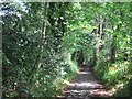
There are currently over 7.5m images from over14,400 individuals and you can help contribute to the project by visiting https://www.geograph.org.uk
Image Map
Images are licensed for reuse under creativecommons.org/licenses/by-sa/2.0
Notes
- Clicking on the map will re-center to the selected point.
- The higher the marker number, the further away the image location is from the centre of the postcode.
Image Listing (87 Images Found)
Images are licensed for reuse under creativecommons.org/licenses/by-sa/2.0
Image
Details
Distance
1
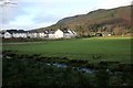
Houses on the edge of Strathblane
These have been built within the last couple of years.
Image: © Richard Sutcliffe
Taken: 1 Jan 2019
0.01 miles
2
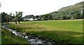
View towards Strathblane
Seen from the Strathblane Railway Path. The Ballagan Burn is in the foreground.
Image: © Richard Sutcliffe
Taken: 28 Aug 2021
0.01 miles
3
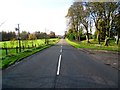
Strathblane to Lennoxtown road
Entering Strathblane from the east.
Image: © Robert Murray
Taken: 1 Nov 2011
0.04 miles
4
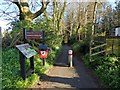
Start of the Strathkelvin Railway Path
The scene is self-explanatory. For context, see Image, a view of this area from further back. This first part of the path follows the old Vicarland Lane.
Image: © Lairich Rig
Taken: 18 Apr 2014
0.05 miles
5
Strathblane Cycle track
A mostly tarred route between Strathblane and Kirkintilloch. This bit is not on the Blane Valley Railway trackbed but most of the route does use the railway. It is very scenic.
Image: © Richard Webb
Taken: 1 Jun 2012
0.05 miles
6
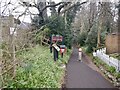
Strathkelvin Railway Walk
Path down to the trackbed in Strathblane.
Image: © Richard Webb
Taken: 20 Apr 2021
0.05 miles
7
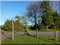
Start of the Strathkelvin Railway Path
For more context, see Image, where this area can be seen in the distance, on the left.
The blue sign at the top of the signpost is for the Strathkelvin Railway Path, which begins here: Image The purple-and-white markers below it are for the John Muir Way, which follows Image to this point, and then follows the Strathkelvin Railway Path for a few kilometres.
Image: © Lairich Rig
Taken: 18 Apr 2014
0.06 miles
8
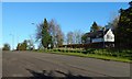
Campsie Road
After heading north along Image, the John Muir Way turns right (east) to take Campsie Road, shown here. Almost opposite the parish church, the route turns right (south), as indicated by a small blue sign that can be seen in the distance, on the left, in the present picture: see Image for a closer look. That sign points to the nearby start of the Strathblane Railway Path. The John Muir Way follows the railway path for a few kilometres.
(At the time of writing, online mapping calls this Strathblane Road, but this appears to be wrong: street signs near the junction with Glasgow Road give the name Campsie Road instead.)
Image: © Lairich Rig
Taken: 18 Apr 2014
0.06 miles
9
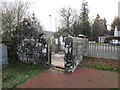
Unroofed building in the SE corner of the churchyard, Strathblane
Image: © Jonathan Thacker
Taken: 22 Nov 2018
0.07 miles
10
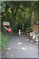
Start of the Strathkelvin Railway Path
This walking and cycle path runs from Strathblane to Lennoxtown in the east, following the route of the old Blane Valley Railway.
Image: © Richard Sutcliffe
Taken: 5 Sep 2015
0.07 miles