IMAGES TAKEN NEAR TO
Fintry, GLASGOW, G63 0XL
Introduction
This page details the photographs taken nearby to G63 0XL by members of the Geograph project.
The Geograph project started in 2005 with the aim of publishing, organising and preserving representative images for every square kilometre of Great Britain, Ireland and the Isle of Man.

There are currently over 7.5m images from over14,400 individuals and you can help contribute to the project by visiting https://www.geograph.org.uk
Image Map
Images are licensed for reuse under creativecommons.org/licenses/by-sa/2.0
Notes
- Clicking on the map will re-center to the selected point.
- The higher the marker number, the further away the image location is from the centre of the postcode.
Image Listing (12 Images Found)
Images are licensed for reuse under creativecommons.org/licenses/by-sa/2.0
Image
Details
Distance
1
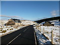
New houses under construction at Muir Toll
There used to be a ruined house on the site of the left-hand house - see Image I think there may have been a wooden cabin-style house on the site of the right-hand house previously.
Image: © Alan O'Dowd
Taken: 2 Feb 2018
0.01 miles
2
Former tollhouse
Surveyed by the Milestone Society. This photograph was taken in 2009. Others in this grid square from 2010 & 2012 show even less remains. Interesting to know what is there now at the end of 2020.
Image: © Chris Minto
Taken: 28 May 2009
0.02 miles
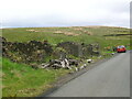
3
Muir Toll
Ruined house on the Crow Road, there is an inhabited house across the road.
Image: © Richard Webb
Taken: 1 Jun 2012
0.02 miles
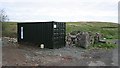
4
Ruined building at Muir Toll on the B822
Image: © Steven Brown
Taken: 9 Nov 2010
0.02 miles
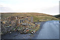
5
Muir Toll
Looking towards Muir Toll on the B822. The old toll house is long gone. It was a ruin when photographed in 2009 Image Nothing of it now remains and instead there are a small group of modern houses.
Image: © Richard Sutcliffe
Taken: 28 Mar 2022
0.07 miles
6

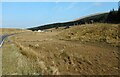
Muir Toll - Campsie Fells
The stream that can just be seen within the small indentation to the right of the road is the initial waterhead of the River Carron, which flows to the River Forth near Falkirk
Image: © Raymond Okonski
Taken: 18 Feb 2007
0.09 miles
7
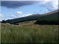
Campsie Fells, the little Carron valley
At this place the Carron is just a rivulet making its way between the high ground either side and it's not until it falls into a much larger burn coming off Campsie Muir near the old toll house that it begins to take form. Meikle Bin lies on the horizon.
Image: © Robert Murray
Taken: 5 Sep 2011
0.10 miles
8
![Campsie Fells, Crow Road [8]](https://s1.geograph.org.uk/geophotos/02/59/77/2597701_099ced26_120x120.jpg)
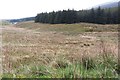
Campsie Fells, Crow Road [8]
View towards the Muir Toll.
Image: © Robert Murray
Taken: 5 Sep 2011
0.16 miles
10
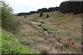
Forest edge by the source of the River Carron
Image: © Alan Reid
Taken: 7 May 2019
0.20 miles