IMAGES TAKEN NEAR TO
Balfron Station, GLASGOW, G63 0NH
Introduction
This page details the photographs taken nearby to G63 0NH by members of the Geograph project.
The Geograph project started in 2005 with the aim of publishing, organising and preserving representative images for every square kilometre of Great Britain, Ireland and the Isle of Man.

There are currently over 7.5m images from over14,400 individuals and you can help contribute to the project by visiting https://www.geograph.org.uk
Image Map
Images are licensed for reuse under creativecommons.org/licenses/by-sa/2.0
Notes
- Clicking on the map will re-center to the selected point.
- The higher the marker number, the further away the image location is from the centre of the postcode.
Image Listing (8 Images Found)
Images are licensed for reuse under creativecommons.org/licenses/by-sa/2.0
Image
Details
Distance
2
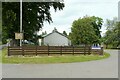
Gartacharn Farm
This is an image to replicate the first submitted for this square in 2005 Image
Image: © Richard Sutcliffe
Taken: 2 Jul 2021
0.04 miles
3
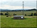
Energy infrastructure
The picture was taken from the road; there was an orange gas pipeline marker there, and a couple of smaller markers. The structure in the foreground is part of the same gas network. The course of the power lines in the background is marked on the map.
The building almost directly behind the pylon is Easter Drumquhassle Cottage (Image); to the left of that are the roofs of the buildings of Easter Drumquhassle Farm (Image).
The left end of the concrete structure (gas network) is useful as a reference in what follows: the point on the skyline directly behind that edge marks a dip in the skyline hills. About halfway between that dip and the left edge of the picture is Pappert Hill (Image, 6 miles, 9.5 km). To the right of that dip is Carman Hill (Image, 9 miles, 14.5 km) and the range of muirs that extend NNW from it. A small part of Ben Bowie (Image, 10 miles, 16 km) is at the far right.
Image: © Lairich Rig
Taken: 25 Aug 2014
0.09 miles
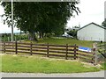
4
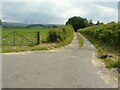
Gartacharn Farm
On a very quiet backroad
Image: © Chris Upson
Taken: 13 Nov 2005
0.09 miles
5
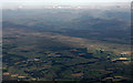
Drymen and The Trossachs from the air
Drymen is on the left where a short section of Endrick Water can also be seen. Slivers of Loch Chon and Loch Ard are visible, with Ben Venue and The Trossachs beyond.
Image: © Thomas Nugent
Taken: 14 Sep 2015
0.09 miles
6
Lane off the minor road
It leads to Lower Gartacharn and Gartacharn Cottage.
Image: © Richard Sutcliffe
Taken: 2 Jul 2021
0.09 miles
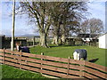
7
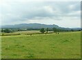
Field beside Gartacharn Farm
With a few grazing cattle.
Image: © Richard Sutcliffe
Taken: 2 Jul 2021
0.16 miles
8
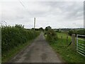
Minor road near to Gartacharn
Looking northward.
Image: © Peter Wood
Taken: 9 Sep 2022
0.17 miles