IMAGES TAKEN NEAR TO
Croftamie, GLASGOW, G63 0HD
Introduction
This page details the photographs taken nearby to G63 0HD by members of the Geograph project.
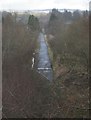
The Geograph project started in 2005 with the aim of publishing, organising and preserving representative images for every square kilometre of Great Britain, Ireland and the Isle of Man.

There are currently over 7.5m images from over14,400 individuals and you can help contribute to the project by visiting https://www.geograph.org.uk
Image Map
Images are licensed for reuse under creativecommons.org/licenses/by-sa/2.0
Notes
- Clicking on the map will re-center to the selected point.
- The higher the marker number, the further away the image location is from the centre of the postcode.
Image Listing (43 Images Found)
Images are licensed for reuse under creativecommons.org/licenses/by-sa/2.0
Image
Details
Distance
1
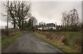
Kilderran, Croftamie
Residential property near to Croftamie.
Image: © Richard Sutcliffe
Taken: 1 Mar 2016
0.01 miles
2
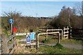
Cycle route near Croftamie
The cycle route (NCN 7) leaves the road here, following the course of the old Forth and Clyde Junction Railway. See Image and Image
The sign on the fence says that this is a permissive path (i.e., it is in use by permission of the landowner), rather than a public right of way.
Image: © Lairich Rig
Taken: 30 Mar 2012
0.04 miles
3
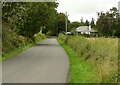
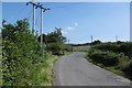
Minor road passing Kilderran
The road runs from Croftamie to Shandon Farm and beyond.
Image: © Richard Sutcliffe
Taken: 20 Sep 2021
0.05 miles
4
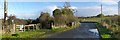
Road and cycle route near Croftamie
The cycle route follows the road up to this point, and then branches off to the left to follow the line of a dismantled railway (Image), passing through the centre of the village of Croftamie: Image
The road on the right leads to the southern end of the village: Image
Image: © Lairich Rig
Taken: 8 Nov 2013
0.05 miles
5
National Cycle Network Route 7
The route leaves the road for a section of rails to trails on to Croftamie.
Image: © Richard Webb
Taken: 17 Aug 2016
0.06 miles
6
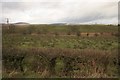
Hedge and fields, Croftamie
The small trees running from left to right across the image are following the line of the old railway line - now a cycle track and part of the John Muir Way.
Image: © Richard Sutcliffe
Taken: 1 Mar 2016
0.06 miles
7
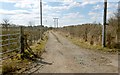
Track to Low Gartachorrans
The viewpoint is just a few metres to the south-east of the point from which a picture of the Image was taken. This first part of the farm track runs parallel to the dismantled line.
Image: © Lairich Rig
Taken: 1 Apr 2013
0.08 miles
8
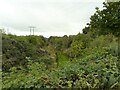
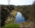
Route of the old railway line
The overgrown route of the Forth and Clyde Junction Railway, which ran from Stirling to Balloch.
Image: © Richard Sutcliffe
Taken: 20 Sep 2021
0.09 miles
9
Old railway line, Croftamie
This section of the old railway line is tarmacked and is part of the John Muir Way. Viewed from the bridge over the old line.
Image: © Richard Sutcliffe
Taken: 1 Mar 2016
0.10 miles
10
Dismantled railway line
This was a cutting on the line of the Forth and Clyde Junction Railway (see Image). For an earlier view of the same cutting, see Image
Image: © Lairich Rig
Taken: 30 Mar 2012
0.11 miles