IMAGES TAKEN NEAR TO
Croftamie, GLASGOW, G63 0EP
Introduction
This page details the photographs taken nearby to G63 0EP by members of the Geograph project.
The Geograph project started in 2005 with the aim of publishing, organising and preserving representative images for every square kilometre of Great Britain, Ireland and the Isle of Man.

There are currently over 7.5m images from over14,400 individuals and you can help contribute to the project by visiting https://www.geograph.org.uk
Image Map
Images are licensed for reuse under creativecommons.org/licenses/by-sa/2.0
Notes
- Clicking on the map will re-center to the selected point.
- The higher the marker number, the further away the image location is from the centre of the postcode.
Image Listing (66 Images Found)
Images are licensed for reuse under creativecommons.org/licenses/by-sa/2.0
Image
Details
Distance
1
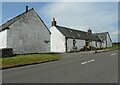
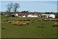
Croftamie Farm
Beside the A809. The porch is in the process of being replaced.
Image: © Richard Sutcliffe
Taken: 2 Jul 2021
0.00 miles
2
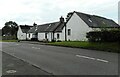
Croftamie Farm
Beside the A809 in Croftamie.
Image: © Richard Sutcliffe
Taken: 4 Aug 2023
0.00 miles
3
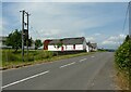
The A809, Croftamie
Looking towards Croftamie Farm.
Image: © Richard Sutcliffe
Taken: 2 Jul 2021
0.01 miles

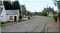
5
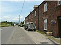
Edmond Terrace, Croftamie
On the A809.
Image: © Richard Sutcliffe
Taken: 2 Jul 2021
0.02 miles
6
Croftamie Farm
The red sandstone building behind the farm is Image The building on the right is a branch of Scottish Stove Centre.
Image: © Lairich Rig
Taken: 30 Mar 2012
0.02 miles
7

Edmond Terrace, Croftamie
This nineteenth-century red sandstone terrace was built for local workers, the employees of "John Edmond and Sons, Wood Merchants, Saw Millers, and Joiners, Croftamie, Drymen Station", as the company was styled at the time (Image was located here, rather than at the village of Drymen, which is at Image).
The saw-mill burned down one night in 1937, and never reopened. The firm was wound up voluntarily, going into liquidation in November of the same year.
As for the building itself, compare Image, which is located several miles away; it is roughly contemporary, is similar in design, and was built for much the same purpose.
Image: © Lairich Rig
Taken: 30 Mar 2012
0.03 miles
8

Grassy bank
The grassy bank leads down to the Catter Burn on the right. The building is part of the Scottish Stove Centre.
Image: © Richard Sutcliffe
Taken: 2 Jul 2021
0.03 miles
9
Croftamie
This photograph was taken from the point where NCN7 (following the former course of a railway line) crosses the main road at Croftamie. It is a view from more or less the same place as Image, but looking in the opposite direction.
Image: © Lairich Rig
Taken: 30 Jun 2011
0.06 miles
10
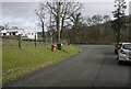
Road junction, Croftamie
Junction of a minor road with the A809.
Image: © Richard Sutcliffe
Taken: 1 Mar 2016
0.06 miles