IMAGES TAKEN NEAR TO
Drumclog Avenue, GLASGOW, G62 8NA
Introduction
This page details the photographs taken nearby to Drumclog Avenue, G62 8NA by members of the Geograph project.
The Geograph project started in 2005 with the aim of publishing, organising and preserving representative images for every square kilometre of Great Britain, Ireland and the Isle of Man.

There are currently over 7.5m images from over14,400 individuals and you can help contribute to the project by visiting https://www.geograph.org.uk
Image Map
Images are licensed for reuse under creativecommons.org/licenses/by-sa/2.0
Notes
- Clicking on the map will re-center to the selected point.
- The higher the marker number, the further away the image location is from the centre of the postcode.
Image Listing (128 Images Found)
Images are licensed for reuse under creativecommons.org/licenses/by-sa/2.0
Image
Details
Distance
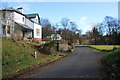
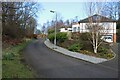
1
NEW
Drumclog Avenue
Private road. Looking towards Mugdock Road.
Image: © Richard Sutcliffe
Taken: 11 Mar 2025
0.01 miles
2
NEW
Drumclog Avenue
Private road.
Image: © Richard Sutcliffe
Taken: 11 Mar 2025
0.02 miles
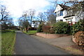
3
NEW
Drumclog Avenue
Private road.
Image: © Richard Sutcliffe
Taken: 11 Mar 2025
0.04 miles
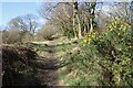
4
NEW
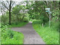
Path, Allander Park
Gorse is in flower.
Image: © Richard Sutcliffe
Taken: 11 Mar 2025
0.04 miles
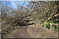
5
NEW
A casualty from Storm Éowyn
One of many trees in the area blown down during Storm Éowyn in January 2025.
Image: © Richard Sutcliffe
Taken: 11 Mar 2025
0.06 miles
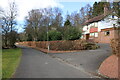
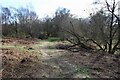
6
NEW
Path to Mosspark Avenue
On the edge of Allander Park.
Image: © Richard Sutcliffe
Taken: 11 Mar 2025
0.07 miles
7
NEW
Drumclog Avenue
Private road. The end of the road is just out of sight.
Image: © Richard Sutcliffe
Taken: 11 Mar 2025
0.07 miles
8
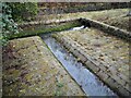
Overflow channel
Water from Mugdock Reservoir (behind the photographer) can be released down this channel by a sluice below a footbridge Image It joins water already flowing down the channel that has come from Mugdock Loch to the north; and will flow into Tannoch Loch to the south.
Image: © Richard Sutcliffe
Taken: 11 Jan 2022
0.10 miles
9
Joining the West Highland Way
The West Highland Way runs left and straight on, here viewed from a minor path from the northern outskirts of Milngavie.
Image: © G Laird
Taken: 25 Jun 2012
0.10 miles
10
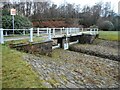
Bridge over overflow channel, Mugdock Reservoir
The footbridge with cast-iron railings is over the overflow channel at the southwest corner of the reservoir. There is a sluice mechanism below to control water levels. See Canmore https://canmore.org.uk/site/292223/glasgow-corporation-water-works-mugdock-reservoir-overflow.
The sides of the reservoir are paved with small stones, which are well seen here.
Image: © Richard Sutcliffe
Taken: 11 Jan 2022
0.10 miles