IMAGES TAKEN NEAR TO
Cromarty Crescent, GLASGOW, G61 3LU
Introduction
This page details the photographs taken nearby to Cromarty Crescent, G61 3LU by members of the Geograph project.
The Geograph project started in 2005 with the aim of publishing, organising and preserving representative images for every square kilometre of Great Britain, Ireland and the Isle of Man.

There are currently over 7.5m images from over14,400 individuals and you can help contribute to the project by visiting https://www.geograph.org.uk
Image Map
Images are licensed for reuse under creativecommons.org/licenses/by-sa/2.0
Notes
- Clicking on the map will re-center to the selected point.
- The higher the marker number, the further away the image location is from the centre of the postcode.
Image Listing (172 Images Found)
Images are licensed for reuse under creativecommons.org/licenses/by-sa/2.0
Image
Details
Distance
1
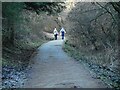
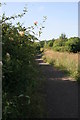
Footpath, near the Craigdhu Wedge
Heading towards Mosshead Primary School.
Image: © Richard Sutcliffe
Taken: 4 Jan 2022
0.03 miles
2
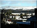
Bearsden rooftops
Looking over the tops of houses in Bearsden towards the Campsie Fells. The snow came from Storm Eunice on 18 February.
Image: © Richard Sutcliffe
Taken: 19 Feb 2022
0.03 miles
3
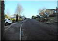
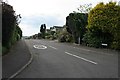
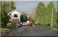
Cromarty Crescent
Looking up the slope.
Image: © Richard Sutcliffe
Taken: 4 Jan 2022
0.05 miles
4
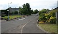
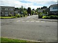
Cromarty Crescent
Seen from the junction with Seafield Avenue.
Image: © Richard Sutcliffe
Taken: 1 Jun 2020
0.07 miles
5
Mar Drive
Seen from the junction with Seafield Avenue.
Image: © Richard Sutcliffe
Taken: 1 Jun 2020
0.07 miles
6
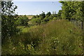
The Craigdhu Wedge
The Craigdhu Wedge is a wedge-shaped area of land between Bearsden and Milngavie, through which flows the Craigdhu Burn. It is a good area for wildlife, and is recognised as a Local Nature Conservation Site by East Dunbartonshire Council.
Image: © Richard Sutcliffe
Taken: 20 Jul 2013
0.09 miles
7
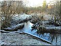
Craigdhu Burn
The burn flows past a frosty scene on a late December afternoon.
Image: © Richard Sutcliffe
Taken: 30 Dec 2020
0.09 miles
8
Elgin Road
At the junction with Stockiemuir Avenue. The steps at the end of the road lead up to an electricity substation and then onto Montrose Drive.
Image: © Richard Sutcliffe
Taken: 30 Jun 2020
0.10 miles
9
The Craigdhu Wedge
Path for walkers and cyclists along the western side of the Craigdhu Wedge. This runs from Milngavie Road (beside McDonald's) to Prestonfield (beside Craigdhu Primary School).
Honeysuckle is in flower in the hedge.
Image: © Richard Sutcliffe
Taken: 20 Jul 2013
0.11 miles
10
The end of Seafield Avenue
A footpath continues beyond the road to join the network of paths through the Craigdhu Wedge.
In the far distance is a tall crane, which is being used in construction of housing close to the fire station on Craigdhu Road.
Image: © Richard Sutcliffe
Taken: 1 Jan 2018
0.11 miles