IMAGES TAKEN NEAR TO
Milngavie Road, GLASGOW, G61 3DQ
Introduction
This page details the photographs taken nearby to Milngavie Road, G61 3DQ by members of the Geograph project.
The Geograph project started in 2005 with the aim of publishing, organising and preserving representative images for every square kilometre of Great Britain, Ireland and the Isle of Man.

There are currently over 7.5m images from over14,400 individuals and you can help contribute to the project by visiting https://www.geograph.org.uk
Image Map
Images are licensed for reuse under creativecommons.org/licenses/by-sa/2.0
Notes
- Clicking on the map will re-center to the selected point.
- The higher the marker number, the further away the image location is from the centre of the postcode.
Image Listing (421 Images Found)
Images are licensed for reuse under creativecommons.org/licenses/by-sa/2.0
Image
Details
Distance
1
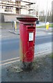
George V pillarbox
Pillarbox (postbox number G61 1016) on Milngavie Road, close to the bottom of Mosshead Road.
Image: © Richard Sutcliffe
Taken: 19 Dec 2016
0.01 miles
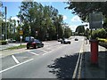
2
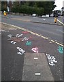
Marks on the pavement
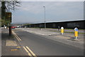
There have been a couple of surveyors around the junction of Mosshead Road and Milngavie Road for a couple of days. The result - lots of colourful markings on the pavement, no doubt indicating the position of various services buried beneath. This is probably in advance of the pavement being dug up in the not too distant future.
Image: © Richard Sutcliffe
Taken: 16 Aug 2020
0.01 miles
3
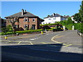
Houses on Mosshead Road
Houses on Mosshead Road viewed from Milngavie Road.
Image: © Philip Halling
Taken: 27 Jun 2019
0.02 miles
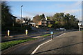
4
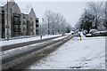
Milngavie Road
The A81 Milngavie Road at the junction with Mosshead Road, after snow.
Image: © Richard Sutcliffe
Taken: 21 Jan 2018
0.02 miles
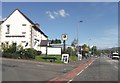
5
New traffic lights on the A81
The lights are at the junction with the road to the Allander Leisure Centre and nearby houses. They came into operation in early June 2021.
Image: © Richard Sutcliffe
Taken: 17 Jun 2021
0.02 miles
6
The Burnbrae on the A81
Next to the Premier Inn
Image: © John Firth
Taken: 17 May 2013
0.02 miles
7
The bottom of Mosshead Road
Junction of Mosshead Road and the A81, Milngavie Road. The Bears Way cycle path is in the foreground.
Image: © Richard Sutcliffe
Taken: 2 Jan 2017
0.02 miles
8
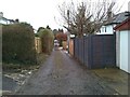
Back lane
The lane runs between the backs of properties on Burnbrae Avenue and Milngavie Road.
Image: © Richard Sutcliffe
Taken: 12 Jan 2022
0.02 miles
9
The fence is up
The long, black-painted fence is to prevent access onto the construction site for new houses. The fence started to go up in March [http://www.geograph.org.uk/photo/4872992] and now there is secure fencing all round the site, work is beginning.
Cala Homes are going to be building 1, 2 and 3 bedroom apartments; and 3, 4 and 5 bedroom homes on the site beside the A81, which used to be a bus company garage.
Image: © Richard Sutcliffe
Taken: 8 May 2016
0.02 miles
10
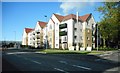
Kilmardinny Heights
These new flats on Milngavie Road are almost complete.
Image: © Richard Sutcliffe
Taken: 9 Sep 2017
0.02 miles