IMAGES TAKEN NEAR TO
Maryhill Road, GLASGOW, G61 1QP
Introduction
This page details the photographs taken nearby to Maryhill Road, G61 1QP by members of the Geograph project.
The Geograph project started in 2005 with the aim of publishing, organising and preserving representative images for every square kilometre of Great Britain, Ireland and the Isle of Man.

There are currently over 7.5m images from over14,400 individuals and you can help contribute to the project by visiting https://www.geograph.org.uk
Image Map
Images are licensed for reuse under creativecommons.org/licenses/by-sa/2.0
Notes
- Clicking on the map will re-center to the selected point.
- The higher the marker number, the further away the image location is from the centre of the postcode.
Image Listing (53 Images Found)
Images are licensed for reuse under creativecommons.org/licenses/by-sa/2.0
Image
Details
Distance
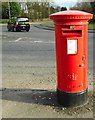
1
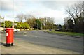
Canniesburn Toll roundabout
The road to the left joins the A81. The pillar box is postbox number G61 1387D.
Image: © Richard Sutcliffe
Taken: 5 Apr 2017
0.06 miles
3
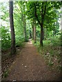
Path through strip of woodland
A small strip of woodland runs down the side of the A81 Maryhill Road. It is part of the Braemar Crescent Open Space.
Image: © Richard Sutcliffe
Taken: 1 Jun 2018
0.07 miles
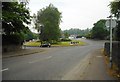
4
Canniesburn Toll Roundabout
Looking towards the roundabout from the road to Bearsden. A road to Milngavie and 2 roads to Glasgow also meet at this roundabout.
Image: © G Laird
Taken: 25 Sep 2010
0.08 miles
5
Pillar box beside Canniesburn Toll roundabout
Postbox number G61 1387D, which has been painted recently.
Image: © Richard Sutcliffe
Taken: 5 Apr 2017
0.08 miles
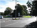
6
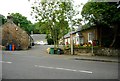
Canniesburn Square
A small group of houses built beside Canniesburn Toll Roundabout and surrounded by two sections of Switchback Road. They are Category C listed [http://portal.historicenvironment.scot/designation/LB22149]
Image: © Richard Sutcliffe
Taken: 1 Jun 2018
0.08 miles
7
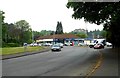
Shops at Canniesburn Toll Roundabout
Image: © Richard Sutcliffe
Taken: 1 Jun 2018
0.09 miles
8
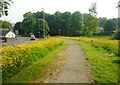
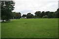
Braemar Crescent Open Space
A small plaque nearby http://www.geograph.org.uk/photo/5795708 declares that:
IN 2000 AD BRAEMAR CRESCENT
OPEN SPACE
WAS DESIGNATED
A MILLENNIUM FIELD
Large numbers of buttercups are in flower.
Image: © Richard Sutcliffe
Taken: 1 Jun 2018
0.09 miles
9
BP Canniesburn and Cluny Park
The A81 runs past the BP filling station at Canniesburn. This park of Cluny Park consists of amenity grassland. A couple of wood pigeons are walking about on the grass.
Image: © Richard Sutcliffe
Taken: 19 Sep 2016
0.09 miles
10
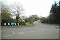
Canniesburn Toll roundabout
Looking towards the A739, Switchback Road.
Image: © Richard Sutcliffe
Taken: 5 Apr 2017
0.10 miles