IMAGES TAKEN NEAR TO
Oronsay Gardens, GLASGOW, G60 5NP
Introduction
This page details the photographs taken nearby to Oronsay Gardens, G60 5NP by members of the Geograph project.
The Geograph project started in 2005 with the aim of publishing, organising and preserving representative images for every square kilometre of Great Britain, Ireland and the Isle of Man.

There are currently over 7.5m images from over14,400 individuals and you can help contribute to the project by visiting https://www.geograph.org.uk
Image Map
Images are licensed for reuse under creativecommons.org/licenses/by-sa/2.0
Notes
- Clicking on the map will re-center to the selected point.
- The higher the marker number, the further away the image location is from the centre of the postcode.
Image Listing (78 Images Found)
Images are licensed for reuse under creativecommons.org/licenses/by-sa/2.0
Image
Details
Distance
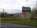
1

Housing on Oronsay Crescent
In Old Kilpatrick.
Image: © Stephen Sweeney
Taken: 16 Jan 2008
0.05 miles
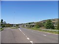
2
Erskine Bridge approach
Slip road from the westbound A82. The sign says it is a W.I.M. Site. This means Weigh In Motion and uses the usual surveillance equipment to match trucks with their weights.
Image: © Richard Webb
Taken: 4 Jan 2016
0.07 miles
3
Road to Old Kilpatrick leading left off the A82
Image: © Elliott Simpson
Taken: 14 May 2016
0.10 miles
4
Erskine Bridge approach
The cycle path does a descent into the woods before climbing back to the bridge. It is easy to continue along the outside of the Armco though. This is the approach from the A82 westbound.
Image: © Richard Webb
Taken: 4 Jan 2016
0.10 miles
5
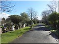
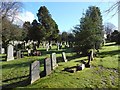
Old Dalnottar Cemetery
This is a view from near the south-western extremity of the cemetery. Click on the end-note title for related images.
Image: © Lairich Rig
Taken: 11 Mar 2014
0.12 miles
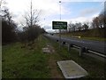
6
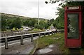
Eastern end of the Erskine Bridge
Approach to the Erskine Bridge on the A898 from the east. The telephone box is now only accessible to pedestrians. There used to be a small lay-by here, but it is no longer open, since a crash barrier was built across it.
Image: © Richard Sutcliffe
Taken: 29 Jul 2018
0.13 miles
7
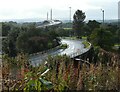
Erskine Bridge and slip road
The slip road carries Glasgow-bound traffic off the bridge (A898) to join the A82.
Image: © Richard Sutcliffe
Taken: 1 Oct 2021
0.13 miles
8

Old Dalnottar Cemetery Offices
The offices are in the white building at the far end of the path, at the northern corner of the cemetery's boundary. The intervening glasshouses were not an original feature of the cemetery, but were erected before the Second World War.
Image: © Lairich Rig
Taken: 11 Mar 2014
0.14 miles
9

Old Dalnottar Cemetery
This is the central avenue of the cemetery. Click on the end-note title for related images.
Image: © Lairich Rig
Taken: 10 Mar 2014
0.14 miles
10
Old Dalnottar Cemetery
This is a general view from the path alongside the north-western boundary. Click on the end-note title for related images.
Image: © Lairich Rig
Taken: 11 Mar 2014
0.14 miles