IMAGES TAKEN NEAR TO
Roman Crescent, GLASGOW, G60 5JX
Introduction
This page details the photographs taken nearby to Roman Crescent, G60 5JX by members of the Geograph project.
The Geograph project started in 2005 with the aim of publishing, organising and preserving representative images for every square kilometre of Great Britain, Ireland and the Isle of Man.

There are currently over 7.5m images from over14,400 individuals and you can help contribute to the project by visiting https://www.geograph.org.uk
Image Map
Images are licensed for reuse under creativecommons.org/licenses/by-sa/2.0
Notes
- Clicking on the map will re-center to the selected point.
- The higher the marker number, the further away the image location is from the centre of the postcode.
Image Listing (95 Images Found)
Images are licensed for reuse under creativecommons.org/licenses/by-sa/2.0
Image
Details
Distance
1
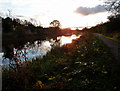
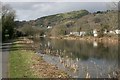
Forth & Clyde Canal, Bowling
Looking towards the Erskine Bridge on an Autumnal morning.
Image: © wfmillar
Taken: 28 Oct 2011
0.04 miles
2

Forth and Clyde Canal
Looking East on the towpath.
Image: © Gordon Dowie
Taken: 7 Nov 2010
0.06 miles
3
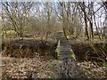
Woodland path near Bowling
Indistinctly visible through the trees on the right are the River Clyde and the Erskine Bridge.
As the map shows, the path closely follows what was once the course of a railway line; the structures crossed by the path at this point were associated with that line. See Image, another remnant of the same line.
Image: © Lairich Rig
Taken: 3 Mar 2014
0.08 miles
4
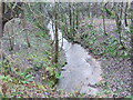
Stream from the Forth and Clyde Canal
This stream flows down from near Glenarbuck House and is unnamed on Ordnance Survey Street view maps.
Image: © Tim Glover
Taken: 31 Dec 2007
0.09 miles
5
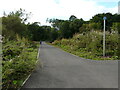
New path
A new path and cycleway has recently been laid, which leads off from the Forth and Clyde Canal towpath. This joins the route of the former Lanarkshire and Dumbartonshire Railway railway. The new path will cross the canal over the old swing bridge at Bowling, over the current railway line and then over the A814 to join the existing route which follows the route of the old line.
Image: © Richard Sutcliffe
Taken: 11 Sep 2021
0.09 miles
6
Forth and Clyde Canal
Looking towards Bowling.
Image: © Richard Sutcliffe
Taken: 29 Feb 2020
0.09 miles
7
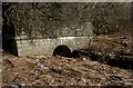
Portal for small un-named burn
The burn emerges onto the shore of the River Clyde, having just come under the line of the former Lanarkshire and Dunbartonshire Railway line - hence the fancy portal. It probably dates from the construction of the line (1896).
Image: © Richard Sutcliffe
Taken: 29 Feb 2020
0.11 miles
8
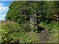
Short curving wall
The wall does not extend far beyond the point where it disappears under the vegetation. It has an opening on the left (the south, that is, the side facing the River Clyde), through which water is discharged: Image / Image
The wall seems incongruous in its present setting alongside a path, but it serves as a reminder that the path follows the course of a dismantled railway line: Image
Image: © Lairich Rig
Taken: 13 May 2018
0.11 miles
9
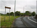
Road into Old Kilpatrick
From Bowling.
Image: © Stephen Sweeney
Taken: 11 May 2007
0.11 miles
10

Water issuing towards the Clyde
A burn is directed under the Forth and Clyde Canal and then under what was once a railway line; the line is now dismantled, its former course serving as a woodland path: Image The present view is from beside the point where the water issues from an opening in a Image / Image
Image: © Lairich Rig
Taken: 13 May 2018
0.12 miles