IMAGES TAKEN NEAR TO
Bowling, GLASGOW, G60 5AF
Introduction
This page details the photographs taken nearby to G60 5AF by members of the Geograph project.
The Geograph project started in 2005 with the aim of publishing, organising and preserving representative images for every square kilometre of Great Britain, Ireland and the Isle of Man.

There are currently over 7.5m images from over14,400 individuals and you can help contribute to the project by visiting https://www.geograph.org.uk
Image Map
Images are licensed for reuse under creativecommons.org/licenses/by-sa/2.0
Notes
- Clicking on the map will re-center to the selected point.
- The higher the marker number, the further away the image location is from the centre of the postcode.
Image Listing (269 Images Found)
Images are licensed for reuse under creativecommons.org/licenses/by-sa/2.0
Image
Details
Distance
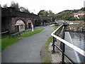
1
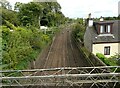
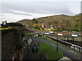
Railway line, Bowling
The line from Glasgow to Dumbarton and Helensburgh. The building on the right is Glenarbuck Cottage.
Image: © Richard Sutcliffe
Taken: 11 Sep 2021
0.01 miles
2
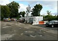
Overflow car park, Bowling Basin
The car park is partly occupied at present by portacabins being used by Scottish Canals, while they undertake work on the adjacent basin.
Image: © Richard Sutcliffe
Taken: 11 Sep 2021
0.01 miles
3
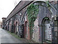
Bricked-up railway arches
Arches within arches under the former Lanarkshire & Dunbartonshire Railway line at the Forth & Clyde Canal basin in Bowling.
See also Image
Image: © Thomas Nugent
Taken: 2 Mar 2008
0.01 miles
4
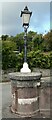
Wall pier and lamp
A squat circular pier at the west end of a curved pink concrete wall with chamfered base and grey concrete cope, with lamp above. It is part of the Category B listed http://portal.historicenvironment.scot/designation/LB18843 Upper Basin at Bowling.
Image: © Richard Sutcliffe
Taken: 11 Sep 2021
0.02 miles
5
Canal towpath from the Bowline
The picture was taken from the Bowline, the new pedestrian and cycle path that uses a disused railway viaduct. It looks towards the point where the Forth and Clyde canal passes under the viaduct.
Image: © Alec MacKinnon
Taken: 25 Nov 2021
0.02 miles
6
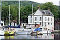
Bowling Harbour
A regeneration of this harbour is now attracting boat owners to make use of the new facilities.
Image: © John McLeish
Taken: 8 Jun 2006
0.02 miles
7
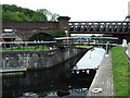
Bowling Basin
Looking towards the old swingbridge and the west end of the Forth & Clyde canal.
Image: © Thomas Nugent
Taken: 8 Aug 2010
0.02 miles
8
Bowling canal basin
The upper of the two basins at the west end of the Forth and Clyde Canal. See also Image
Image: © Thomas Nugent
Taken: 27 Apr 2015
0.02 miles
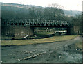
9
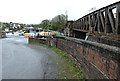
Viaduct, Bowling Basin
The disused Caledonian and Dunbartonshire Junction Railway crosses the Forth and Clyde Canal and the currently open railway. Most under the arches properties are vacant.
Image: © Richard Webb
Taken: 1 Sep 2009
0.02 miles
10
Old Railway Bridge, Bowling
Crosses the Forth and Clyde Canal. A swing Bridge probably steam operated in its day, now non operational
Image: © william craig
Taken: Unknown
0.03 miles