IMAGES TAKEN NEAR TO
Salterland Road, GLASGOW, G53 7TQ
Introduction
This page details the photographs taken nearby to Salterland Road, G53 7TQ by members of the Geograph project.
The Geograph project started in 2005 with the aim of publishing, organising and preserving representative images for every square kilometre of Great Britain, Ireland and the Isle of Man.

There are currently over 7.5m images from over14,400 individuals and you can help contribute to the project by visiting https://www.geograph.org.uk
Image Map
Images are licensed for reuse under creativecommons.org/licenses/by-sa/2.0
Notes
- Clicking on the map will re-center to the selected point.
- The higher the marker number, the further away the image location is from the centre of the postcode.
Image Listing (52 Images Found)
Images are licensed for reuse under creativecommons.org/licenses/by-sa/2.0
Image
Details
Distance
1
River Levern, Barrhead
View downstream from Salterland Bridge.
Image: © wfmillar
Taken: 14 Mar 2012
0.05 miles
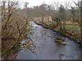
2
Levern Water
Salterland Road bridge and railway viaduct for the Kilmarnock/Glasgow railway line.
Image: © wfmillar
Taken: 14 Mar 2012
0.06 miles
3
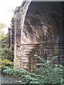
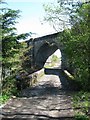
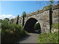
Salterland Viaduct
This view of the 1847 railway viaduct, erected in 1847 by the Glasgow, Barrhead and Neilston Direct Railway, shows clearly the large skewed ashlar blocks in the arch over the Levern Water. The viaduct is Category B listed.
Image: © Richard Sutcliffe
Taken: 15 Oct 2019
0.06 miles
4
Salterland Viaduct
This view of the 1847 railway viaduct, erected in 1847 by the Glasgow, Barrhead and Neilston Direct Railway, shows clearly the large skewed ashlar blocks in the arch over the Levern Water. The viaduct is Category B listed.
Image: © Richard Sutcliffe
Taken: 15 Oct 2019
0.06 miles
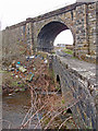
5
Road Bridge and Railway Bridge on Salterland Road north-east of Barrhead
Salterland Road crosses the Levern Water at this point, though on the day of my visit, you couldn't travel much further. The road was being used as a dump not far past the railway bridge.
The railway bridge carries a section of the Glasgow South Western Line between Barrhead and Nitshill railway stations.
Image: © G Laird
Taken: 29 Apr 2014
0.06 miles
6
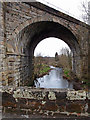
Levern Water
Salterland Road bridge and railway viaduct for the Kilmarnock/Glasgow railway line. Skew bridges a feat of engineering!
Image: © wfmillar
Taken: 14 Mar 2012
0.06 miles
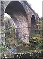
7
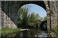
Bridge and viaduct over the Levern Water
Seen through one of the arches of the Salterland Viaduct, carrying the Glasgow to Barrhead railway line, a small lorry on Salterland Road crosses the narrow 18th century bridge over the Levern Water.
Image: © Richard Sutcliffe
Taken: 11 May 2016
0.06 miles
9
Salterland Viaduct
See, for example, Image for further information. It crosses Image here. For the black objects dotted about the masonry, see Image
Image: © Lairich Rig
Taken: 26 Aug 2019
0.06 miles
10

Train crossing the Salterland Viaduct
A Barrhead to Glasgow train crosses the Salterland Viaduct above the Levern Water.
Image: © Richard Sutcliffe
Taken: 11 May 2016
0.07 miles