IMAGES TAKEN NEAR TO
Woodhead Road, GLASGOW, G53 7NN
Introduction
This page details the photographs taken nearby to Woodhead Road, G53 7NN by members of the Geograph project.
The Geograph project started in 2005 with the aim of publishing, organising and preserving representative images for every square kilometre of Great Britain, Ireland and the Isle of Man.

There are currently over 7.5m images from over14,400 individuals and you can help contribute to the project by visiting https://www.geograph.org.uk
Image Map
Images are licensed for reuse under creativecommons.org/licenses/by-sa/2.0
Notes
- Clicking on the map will re-center to the selected point.
- The higher the marker number, the further away the image location is from the centre of the postcode.
Image Listing (154 Images Found)
Images are licensed for reuse under creativecommons.org/licenses/by-sa/2.0
Image
Details
Distance
1
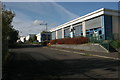
Museum Business Park
Industrial units on Woodhead Road.
Image: © Richard Sutcliffe
Taken: 25 Oct 2016
0.01 miles
2
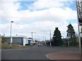
The new industrial estate near the museum resource centre
Image: © Elliott Simpson
Taken: 28 Mar 2009
0.02 miles
3
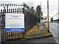
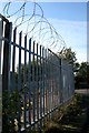
Twisted, Woodhead Road, Nitshill
Sign at the entrance to a hygiene and packaging company on Woodhead Road. The security measures at the top of the fence match the company name!
Note the state of the pavement.
Image: © Richard Sutcliffe
Taken: 12 Jan 2018
0.02 miles
4
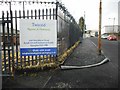
Twisted, Woodhead Road, Nitshill
Sign at the entrance to a hygiene and packaging company on Woodhead Road. The security measures at the top of the fence match the company name!
Note the state of the pavement compared with a few weeks earlier [http://www.geograph.org.uk/photo/5654900].
Image: © Richard Sutcliffe
Taken: 19 Feb 2018
0.02 miles
5
Keep Out!
Security wire on top of the fence of Glasgow City Council's Land Services Nitshill Depot on Woodhead Road.
Image: © Richard Sutcliffe
Taken: 25 Oct 2016
0.03 miles
6
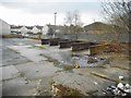
Former Council Roads Depot
Empty storage bays.
Image: © Richard Sutcliffe
Taken: 12 Jan 2018
0.04 miles
7
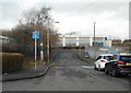
Looking towards Woodhead Road
There used to be bollards across Weensmoor Road, just beyond the cars, making this a cul-de-sac (hence the road sign). It is now possible to drive through to Woodhead Road.
Image: © Richard Sutcliffe
Taken: 19 Feb 2018
0.05 miles
8
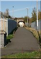
Footpath under the railway
The path leads from Woodhead Road to waste ground on the other side of the railway. This leads to Nitshill Road, and Nitshill railway station.
Image: © Richard Sutcliffe
Taken: 25 Oct 2016
0.05 miles
9
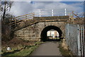
Bridge under the railway
The path leads from Woodhead Road to waste ground on the other side of the railway. This leads to Nitshill Road, and Nitshill railway station.
Image: © Richard Sutcliffe
Taken: 6 Mar 2017
0.05 miles
10
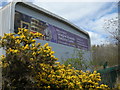
Glasgow Museums Resource Centre
The east end of the building. The large graphic was added to the end of the building so it could be seen from passing trains.
Image: © Richard Sutcliffe
Taken: 19 Apr 2016
0.06 miles