IMAGES TAKEN NEAR TO
Faskin Crescent, GLASGOW, G53 7HD
Introduction
This page details the photographs taken nearby to Faskin Crescent, G53 7HD by members of the Geograph project.
The Geograph project started in 2005 with the aim of publishing, organising and preserving representative images for every square kilometre of Great Britain, Ireland and the Isle of Man.

There are currently over 7.5m images from over14,400 individuals and you can help contribute to the project by visiting https://www.geograph.org.uk
Image Map
Images are licensed for reuse under creativecommons.org/licenses/by-sa/2.0
Notes
- Clicking on the map will re-center to the selected point.
- The higher the marker number, the further away the image location is from the centre of the postcode.
Image Listing (37 Images Found)
Images are licensed for reuse under creativecommons.org/licenses/by-sa/2.0
Image
Details
Distance
1
Faskin Road, Hurlet
If the road is followed in the opposite direction, it turns sharply to the right, but continuing in the same direction from the corner is a path (Image) that is about 150 metres long, and which is just within the woodland edge shown on the left in Image A line of trees separates the path from the grassy space shown there.
Image: © Lairich Rig
Taken: 26 Aug 2019
0.04 miles
2
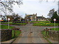
Househill Parks Depot
Glasgow City Council Househill Parks Depot
Image: © Iain Thompson
Taken: 22 Apr 2006
0.06 miles
3
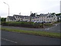
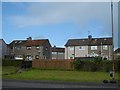
Hurlethill Court
Very plush housing in the Hurlet area of Glasgow.
Image: © Stephen Sweeney
Taken: 25 May 2009
0.08 miles
4
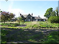
Former Househill Parks Depot
It is interesting to compare this photograph with Image The buildings and land have now fallen into disrepair.
Image: © G Laird
Taken: 29 Apr 2014
0.09 miles
5
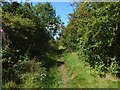
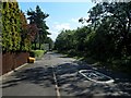
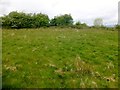
A path from Faskin Road
The path, about 150 metres long, heads northwest from where Faskin Road makes a sharp turn. To the right of the path is woodland. On the left, a line of trees separates this path from the grassy space shown in Image
Behind the photographer is Image
Image: © Lairich Rig
Taken: 26 Aug 2019
0.10 miles
7
Hurlet Hill to Faskin Road
This continuation of a Image leads to Image Behind the woodland edge on the left, and concealed by a line of trees, is a Image
Image: © Lairich Rig
Taken: 26 Aug 2019
0.10 miles
8
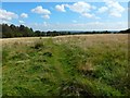
Househill Park
A long park beside the Levern Water.
Image: © Richard Webb
Taken: 25 Sep 2015
0.12 miles
9
Hurlet Hill
Trig, summit and Glasgow completion.
Name: Hurlet Hill
Hill number: 13749
Height: 66m / 217ft
Parent (Ma/M): 1686 Corse Hill
Section: 27A: Ayr to the River Clyde
County/UA: Glasgow (UA)
Class: Tump (0-99m)
Grid ref: NS 51403 61196
Summit feature: no feature
Drop: 34m
Col: 32m NS509606
Image: © Rude Health
Taken: 27 May 2015
0.14 miles
10
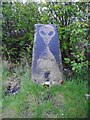
Alien trig point
The trig point at the top of Hurlet Hill has been given the X-Files treatment.
Image: © Richard Sutcliffe
Taken: 5 May 2018
0.14 miles