IMAGES TAKEN NEAR TO
Linthaugh Road, GLASGOW, G53 5QY
Introduction
This page details the photographs taken nearby to Linthaugh Road, G53 5QY by members of the Geograph project.
The Geograph project started in 2005 with the aim of publishing, organising and preserving representative images for every square kilometre of Great Britain, Ireland and the Isle of Man.

There are currently over 7.5m images from over14,400 individuals and you can help contribute to the project by visiting https://www.geograph.org.uk
Image Map
Images are licensed for reuse under creativecommons.org/licenses/by-sa/2.0
Notes
- Clicking on the map will re-center to the selected point.
- The higher the marker number, the further away the image location is from the centre of the postcode.
Image Listing (57 Images Found)
Images are licensed for reuse under creativecommons.org/licenses/by-sa/2.0
Image
Details
Distance
1
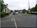
Linthaugh Road, Pollok
From Brockburn Road.
Image: © Stephen Sweeney
Taken: 25 May 2009
0.03 miles
2
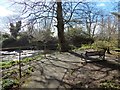
Rosshall Park: riverside viewpoint
The park's River Walk (Image) leads to this area. The confluence of the White Cart Water and the Levern Water can be seen from this viewpoint.
Image: © Lairich Rig
Taken: 24 Mar 2014
0.08 miles
3
Path to Crookston Castle
From Towerside Crescent.
Image: © Stephen Sweeney
Taken: 25 May 2009
0.12 miles
4
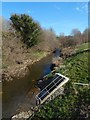
The Levern Water
The view is from the road bridge that carries Linthaugh Road over the river.
Image: © Lairich Rig
Taken: 24 Mar 2014
0.12 miles
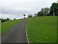
5
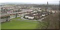
View from Crookston Castle - WSW
The viewpoint for this picture was the top of Crookston Castle.
The nearest houses at the left-hand edge of the image stand alongside Brockburn Road. The closest houses just right of centre, where a car is rounding a corner, are on Towerside Crescent.
The tower visible in the right-hand side of the image belongs to Leverndale Hospital, which was built in 1895, and was formerly known as Hawkhead Asylum. At the time of writing, Leverndale Hospital, which now includes more recent buildings, was still in use, and served as a psycho-geriatric unit.
The distant hills in the left of the image are the area around Gleniffer Braes.
Image: © Lairich Rig
Taken: 9 Dec 2005
0.12 miles
6
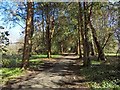
Rosshall Park: the river walk
This section of the path is close to the confluence of the White Cart Water and the Levern Water.
Image: © Lairich Rig
Taken: 24 Mar 2014
0.12 miles
7
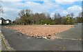
Former site of Howford Primary School
At the time this picture was taken, the building was still shown in online mapping, but, as I learned in an interesting chat with a woman passing by, a teenage girl was charged with wilful fire-raising after the building (by then out of use) burned down in July 2018. The site is adjacent to Crookston Road.
Image: © Lairich Rig
Taken: 11 Apr 2019
0.13 miles
8
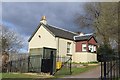
Cottage at entrance to Crookston Castle, Glasgow
Image: © Leslie Barrie
Taken: 27 Apr 2013
0.14 miles
9
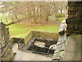
Position of causeway in Crookston Castle's ringworks
This picture was taken from an upper floor of Crookston Castle; see the main description: Image The existing ruined castle dates from the early fifteenth century, but the defensive earthworks were associated with an earlier (twelfth century) wooden structure that stood on the same site.
As was mentioned in the main description, the position of an original causeway in the defensive ringwork that surrounds the castle site can still be discerned today. The defensive ditch is clearly visible here, but note a path that crosses it near the position of the red van (which is parked in front of a nearby lodge). It is at this point, where the path crosses the ditch, that the original causeway would have been located.
In this image, on the near side of the ditch, just to the right of the path, it is just possible to make out something set into the grass. This is a plaque on a stone, and it reads:
"Gatehouse - This is where the gatehouse would always have stood. The first Crookston Castle was built by Robert Croc, who gave his name to the area, before 1180. You can still see the mighty bank and ditch which protected his timber hall, kitchen, bakehouse and stables. The stone castle was built by the Stewarts of Darnley around 1400. This is a carefully planned tower house, with a smaller symmetrical tower at each corner. The castle was damaged in a siege in 1489, and although partially rebuilt was in ruins by 1600."
Image: © Lairich Rig
Taken: 9 Dec 2005
0.15 miles
10
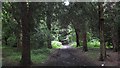
Path, Ross Hall Park
A riverside path running through dark woodlands in Rosshall Park. This was once the grounds of a large house.
Plenty of alternative spellings here, maps from 1898 have Ross Hill, and of course show it to be far out into rural Renfrewshire between Glasgow and Paisley. Glasgow has grown a lot in the last 100 years or so, often fragments of the grounds of country estates have survived as parks.
Image: © Richard Webb
Taken: 16 Jun 2009
0.15 miles