View from Crookston Castle - WSW
Introduction
The photograph on this page of View from Crookston Castle - WSW by Lairich Rig as part of the Geograph project.
The Geograph project started in 2005 with the aim of publishing, organising and preserving representative images for every square kilometre of Great Britain, Ireland and the Isle of Man.

There are currently over 7.5m images from over 14,400 individuals and you can help contribute to the project by visiting https://www.geograph.org.uk
View from Crookston Castle - WSW
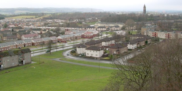
Image: © Lairich Rig Taken: 9 Dec 2005
The viewpoint for this picture was the top of Crookston Castle. The nearest houses at the left-hand edge of the image stand alongside Brockburn Road. The closest houses just right of centre, where a car is rounding a corner, are on Towerside Crescent. The tower visible in the right-hand side of the image belongs to Leverndale Hospital, which was built in 1895, and was formerly known as Hawkhead Asylum. At the time of writing, Leverndale Hospital, which now includes more recent buildings, was still in use, and served as a psycho-geriatric unit. The distant hills in the left of the image are the area around Gleniffer Braes.
Images are licensed for reuse under creativecommons.org/licenses/by-sa/2.0
Image Location
Latitude
55.834525
Longitude
-4.358293