IMAGES TAKEN NEAR TO
Chirnside Road, GLASGOW, G52 2LG
Introduction
This page details the photographs taken nearby to Chirnside Road, G52 2LG by members of the Geograph project.
The Geograph project started in 2005 with the aim of publishing, organising and preserving representative images for every square kilometre of Great Britain, Ireland and the Isle of Man.

There are currently over 7.5m images from over14,400 individuals and you can help contribute to the project by visiting https://www.geograph.org.uk
Image Map
Images are licensed for reuse under creativecommons.org/licenses/by-sa/2.0
Notes
- Clicking on the map will re-center to the selected point.
- The higher the marker number, the further away the image location is from the centre of the postcode.
Image Listing (35 Images Found)
Images are licensed for reuse under creativecommons.org/licenses/by-sa/2.0
Image
Details
Distance
1

Carnegie Avenue
Just off Hillington Road, looking towards Hillington East railway station.
Image: © Thomas Nugent
Taken: 4 Sep 2010
0.05 miles
2
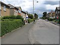
Chirnside Road
Long straight residential street running parallel with the railway which runs behind the houses on the left.
Image: © Richard Webb
Taken: 16 Jun 2009
0.08 miles
3
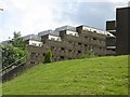
Chirnside Place
Stepped flats with deck access built on a hillside. There are six blocks set in parkland.
Image: © Richard Webb
Taken: 16 Jun 2009
0.10 miles
4
Balantyne Road
The sign reads "Ballantyne Road", but maps show it as "Ballantine Avenue".
Image: © Thomas Nugent
Taken: 4 Sep 2010
0.11 miles
5
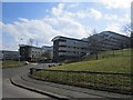
Chirnside Place
The flats have changed their appearance since 2009. Image
Image: © Richard Webb
Taken: 9 Apr 2013
0.12 miles
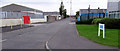
6
Victor Lighting
Factory making lighting for use in hazardous areas. View from the inside of a coned off roundabout on the junction of Carnegie Road and Sandwood Road.
Image: © Richard Webb
Taken: 16 Jun 2009
0.14 miles
7
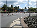
Sandwood Road
View from the middle of a busy road. The roundabout is reduced to one lane due to work to reinstate the missing central deck of the railway bridge to accommodate a third track between Shields Junction and Arkleston Junction.
Image: © Richard Webb
Taken: 16 Jun 2009
0.14 miles
8
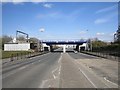
Rebuilt railway bridge
Last time I was here, in 2009 the bridge was being rebuilt. Image
Image: © Richard Webb
Taken: 9 Apr 2013
0.14 miles
9

Roundabout on Hillington Road
Tilemania marks the entrance to Queen Elizabeth Avenue on the left.
Image: © Thomas Nugent
Taken: 4 Sep 2010
0.15 miles
10
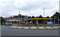
Roundabout on Hillington Road
At the junction with Queen Elizabeth Avenue.
Image: © Thomas Nugent
Taken: 4 Sep 2010
0.15 miles