IMAGES TAKEN NEAR TO
Shieldhall Road, GLASGOW, G51 4XB
Introduction
This page details the photographs taken nearby to Shieldhall Road, G51 4XB by members of the Geograph project.
The Geograph project started in 2005 with the aim of publishing, organising and preserving representative images for every square kilometre of Great Britain, Ireland and the Isle of Man.

There are currently over 7.5m images from over14,400 individuals and you can help contribute to the project by visiting https://www.geograph.org.uk
Image Map
Images are licensed for reuse under creativecommons.org/licenses/by-sa/2.0
Notes
- Clicking on the map will re-center to the selected point.
- The higher the marker number, the further away the image location is from the centre of the postcode.
Image Listing (17 Images Found)
Images are licensed for reuse under creativecommons.org/licenses/by-sa/2.0
Image
Details
Distance
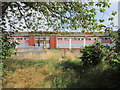
1

Former Drumoyne Primary School on Shieldhall Road
Drumoyne Primary School has now been merged with Elder Park and Greenfield Primary Schools and Govan Family Learning Centre as Pirie Park Primary School on Langlands Road.
Image: © G Laird
Taken: 2 Apr 2010
0.08 miles
3
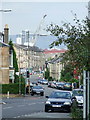
Craigton Road
Govan shipyards and the Glasgow Harbour development can be seen beyond.
Image: © Thomas Nugent
Taken: 30 Sep 2007
0.17 miles
4
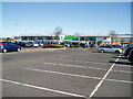
Bakers, Drymoyne
On the busy Shieldhall Road a popular stopping point at lunch time in Glasgow.
Image: © wfmillar
Taken: 15 Apr 2011
0.19 miles
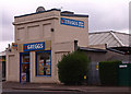
7
Car Engine Repair Centre
Repair centre at the end of Drumoyne Road, just beneath the M8 motorway embankment. Littered with clapped out old engines. Not sure I'd take my car here!
Image: © Chris Upson
Taken: 29 Sep 2005
0.21 miles
9
Luss Road
The site was shown as agricultural land on the first edition 6" map (mid 19th century) and by 1890 was an industrial area.
Image: © Richard Webb
Taken: 9 Apr 2013
0.22 miles
10
The former Drumoyne Primary School
On Shieldhall Road.
Image: © Ian S
Taken: 26 Aug 2013
0.22 miles