IMAGES TAKEN NEAR TO
Hazelden Park, GLASGOW, G44 3HA
Introduction
This page details the photographs taken nearby to Hazelden Park, G44 3HA by members of the Geograph project.
The Geograph project started in 2005 with the aim of publishing, organising and preserving representative images for every square kilometre of Great Britain, Ireland and the Isle of Man.

There are currently over 7.5m images from over14,400 individuals and you can help contribute to the project by visiting https://www.geograph.org.uk
Image Map
Images are licensed for reuse under creativecommons.org/licenses/by-sa/2.0
Notes
- Clicking on the map will re-center to the selected point.
- The higher the marker number, the further away the image location is from the centre of the postcode.
Image Listing (57 Images Found)
Images are licensed for reuse under creativecommons.org/licenses/by-sa/2.0
Image
Details
Distance
1
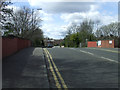
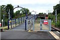
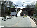
Muirend Road
The bridge over the railway tracks at Muirend station.
Image: © Thomas Nugent
Taken: 27 Apr 2013
0.04 miles
2
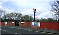
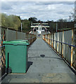
Muirend railway station
The Muirend Road entrance to the station.
Image: © Thomas Nugent
Taken: 27 Apr 2013
0.06 miles
3
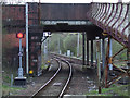
Tracks south of Muirend railway station
Passing under the Muirend Road bridge, viewed from the station platform.
Image: © Thomas Nugent
Taken: 27 Apr 2013
0.07 miles
4
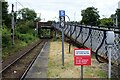
The end of Platform 2, Muirend Station
Looking towards the bridge carrying Muirend Road over the railway.
Image: © Richard Sutcliffe
Taken: 13 Jul 2024
0.08 miles
5
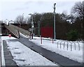
Ramp to Muirend Road
The ramp leads from the island platform of Muirend Station up to Muirend Road. The station is Category B listed https://portal.historicenvironment.scot/designation/LB33942 and was built by the Lanarkshire & Ayrshire Railway about 1903.
Image: © Richard Sutcliffe
Taken: 13 Jul 2024
0.08 miles
6
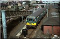
Glasgow 'Blue Train' at Muirend, 1966
This was part of the second stage of electrification of Glasgow suburban services including the Cathcart Circle and the line to Neilston, inaugurated in 1962. The train is a single 3-car set in original condition with blue livery and wrap-round windows to the cab.
The station building in the background survives and is Listed Category B. Although not included in the Listing, the original ornate ramp down from Muirend Road has also survived https://www.geograph.org.uk/photo/3438515
Image: © Alan Murray-Rust
Taken: 24 Mar 1966
0.09 miles
7
Muirend railway station
The south side of the station platform. See the top of the ramp here Image
Image: © Thomas Nugent
Taken: 30 Dec 2009
0.09 miles
8
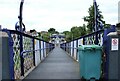
Ramp down to Muirend station
The ramp leads from Muirend Road to the platform of the Category B listed https://portal.historicenvironment.scot/designation/LB33942 station, built by the Lanarkshire & Ayrshire Railway and dating from about 1903.
This view is similar to the first image for this square Image, taken and submitted in 2005.
Image: © Richard Sutcliffe
Taken: 13 Jul 2024
0.09 miles
9
Muirend railway station
The ramp from the single island platform to Muirend Road.
Image: © Thomas Nugent
Taken: 27 Apr 2013
0.09 miles
10
Muirend railway station
Looking down the access ramp from Muirend Road.
The station building is a Category B Listed structure, described by Historic Scotland as follows...
Style of James Millar. Late 19th/early 20th century. Station with Art Nouveau detailing, free standing on island platform, and with deep cantilevered flat canopy, decorative timber valance with pierced heart ornament. Red brick and timber, small-paned openings, slated main roof with red ridging, deep-corniced brick axial stacks; distinctive aedicular notice boards.
Image: © Thomas Nugent
Taken: 27 Apr 2013
0.09 miles