IMAGES TAKEN NEAR TO
Berridale Avenue, GLASGOW, G44 3AE
Introduction
This page details the photographs taken nearby to Berridale Avenue, G44 3AE by members of the Geograph project.
The Geograph project started in 2005 with the aim of publishing, organising and preserving representative images for every square kilometre of Great Britain, Ireland and the Isle of Man.

There are currently over 7.5m images from over14,400 individuals and you can help contribute to the project by visiting https://www.geograph.org.uk
Image Map (Loading...)


Getting Data...Please wait
Leaflet Map data © OpenStreetMap
Images are licensed for reuse under creativecommons.org/licenses/by-sa/2.0
Notes
- Clicking on the map will re-center to the selected point.
- The higher the marker number, the further away the image location is from the centre of the postcode.
Image Listing (104 Images Found)
Images are licensed for reuse under creativecommons.org/licenses/by-sa/2.0
Image
Details
Distance
1
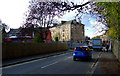
Delvin Road
Cathcart railway station is to the right.
Image: © Thomas Nugent
Taken: 30 Oct 2010
0.07 miles
2

Kings Park Secondary School
Viewed from Cathcart railway station.
Image: © Thomas Nugent
Taken: 30 Oct 2010
0.08 miles
3

Cathcart railway station
The underpass, from the Delvin Road end of the station.
Image: © Thomas Nugent
Taken: 30 Oct 2010
0.08 miles
4

Old gas lamp stand
At the Delvin Road entrance to Cathcart railway station.
Image: © Thomas Nugent
Taken: 30 Oct 2010
0.08 miles
5

Cathcart railway station
The glossy white brick lining of the underpass helps reflect the artificial and day light within the underpass.
Image: © Thomas Nugent
Taken: 30 Oct 2010
0.08 miles
6

White Cart railway bridges
Viewed from Cathcart railway station. The bridge in the distance carries the line from Kings Park station.
Image: © Thomas Nugent
Taken: 30 Oct 2010
0.09 miles
7
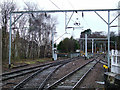
Cathcart railway station
Points at the southwest end of the platform. The Cathcart Circle line curves round to the right, the line to Muirend and Neilston curves away to the left in the distance.
Image: © Thomas Nugent
Taken: 29 Dec 2012
0.10 miles
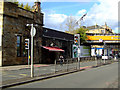
8
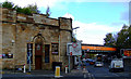
Beechings Bar
A former railway station (hence the name) possibly the original Cathcart station. The current Cathcart station is to the right of the orange bridge. A line once ran above the pub and crossed the road between the photographer and the existing bridge.
Image: © Thomas Nugent
Taken: 30 Oct 2010
0.10 miles
9
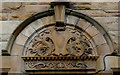
Beechings Bar
Ornate stonework above the door of the former railway station Image
Image: © Thomas Nugent
Taken: 30 Oct 2010
0.10 miles
10
Beechings Bar
A former railway station, now a pub. See also Image and Image The remains of a former bridge can be seen above the canopy.
Image: © Thomas Nugent
Taken: 30 Oct 2010
0.10 miles