IMAGES TAKEN NEAR TO
Maxwell Road, GLASGOW, G41 1QP
Introduction
This page details the photographs taken nearby to Maxwell Road, G41 1QP by members of the Geograph project.
The Geograph project started in 2005 with the aim of publishing, organising and preserving representative images for every square kilometre of Great Britain, Ireland and the Isle of Man.

There are currently over 7.5m images from over14,400 individuals and you can help contribute to the project by visiting https://www.geograph.org.uk
Image Map
Images are licensed for reuse under creativecommons.org/licenses/by-sa/2.0
Notes
- Clicking on the map will re-center to the selected point.
- The higher the marker number, the further away the image location is from the centre of the postcode.
Image Listing (121 Images Found)
Images are licensed for reuse under creativecommons.org/licenses/by-sa/2.0
Image
Details
Distance
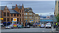
1
Pollokshaws Road at St Andrews Cross, Glasgow
Image: © Leslie Barrie
Taken: 27 Apr 2013
0.01 miles
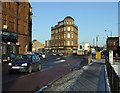
2
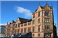
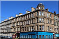
St Andrews Cross
Built in 1894-6 for the YMCA, this ‘B’ Listed building at the corner of Pollokshaws Road and Maxwell Road has been converted to flats and ground floor retail use.
Image: © Thomas Nugent
Taken: 31 Jul 2011
0.02 miles
3
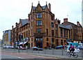
St Andrews Cross
Built in 1894-6 for the YMCA, this ‘B’ Listed building at the corner of Pollokshaws Road and Maxwell Road has been converted to flats and ground floor retail use.
Image: © Thomas Nugent
Taken: 31 Jul 2011
0.02 miles
4
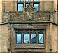
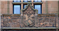
YMCA building at St Andrews Cross
Detail of the crumbling carving above the main door. See also Image
Image: © Thomas Nugent
Taken: 31 Jul 2011
0.02 miles
5
YMCA building at St Andrews Cross
Image: © Thomas Nugent
Taken: 31 Jul 2011
0.02 miles
6
Corner of Maxwell Road and Eglinton Street, Glasgow
Image: © Leslie Barrie
Taken: 27 Apr 2013
0.02 miles
7
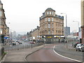
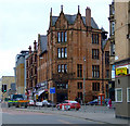
St. Andrew's Cross
Better known now as Eglinton Toll and really no longer a cross with the pavement division between Eglinton Street (A77) on the left and Victoria Road on the right.
This division did not exist many years ago in the days of the trams when there used to be a large shelter at the tram stop in front of the dominant and highly distinctive tenement building in the centre of the photograph.
Image: © G Laird
Taken: 26 Dec 2008
0.02 miles
8
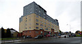
Plaza Apartments at Eglinton Toll
Built on the site of the Plaza Ballroom https://canmore.org.uk/site/281997/glasgow-victoria-road-plaza-ballroom , part of which is incorporated in the apartment building.
Image: © Thomas Nugent
Taken: 15 Oct 2016
0.03 miles
9
St Andrews Cross
Looking north into the cross from Victoria Road. The new M74 Port Eglinton viaduct can be seen crossing Eglinton Street in the distance.
Image: © Thomas Nugent
Taken: 31 Jul 2011
0.04 miles
10
St Andrew's Cross
Not actually a cross any more as Pollokshaws Road and Victoria Road no longer meet here.
Image: © Thomas Nugent
Taken: 6 Jan 2010
0.04 miles