1
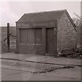
Flattened weighbridge building
The machine is sitting on top of a pile of rubble - all that remains of Public Weighbridge No 1 on St Vincent Crescent. It was being demolished in preparation for building on what is today Minerva Way. The actual weighbridge can be seen in the foreground. In the far distance is the Finnieston Crane.
Up until 1960 the area behind the weighbridge was Stobcross Goods and Mineral Yard, with many railway sidings.
Scanned from a Kodachrome colour reversal (slide) film.
Image: © Richard Sutcliffe
Taken: Unknown
0.01 miles
2
Public Weighbridge No 1
Weighbridge on St Vincent Crescent. It was later demolished in preparation for building on what is today Minerva Way
Image
Up until 1960 the area behind the weighbridge was Stobcross Goods and Mineral Yard, with many railway sidings.
Image: © Richard Sutcliffe
Taken: 1 Jan 1983
0.01 miles
3
St Vincent Crescent
Looking towards Minerva Street.
Image: © Richard Sutcliffe
Taken: 16 Jun 2015
0.02 miles
4
Scaffolding, St Vincent Crescent
Numbers 21 and 20 St Vincent Crescent, part of a long range of tenements designed by Alexander Kirkland, dating from circa 1855. They are all Category A listed http://portal.historicenvironment.scot/designation/LB33128. The scaffolding was up while the properties were stone cleaned, and essential repairs were undertaken as part of an improvement scheme in 1985. The photograph is taken from an area that had been railway sidings, but at this date was waste ground.
Image: © Richard Sutcliffe
Taken: Unknown
0.02 miles
5
20 St Vincent Crescent
Category A listed tenement [http://portal.historicenvironment.scot/designation/LB33128] dating from about 1855, by Alexander Kirkland.
Image: © Richard Sutcliffe
Taken: 17 Apr 2019
0.02 miles
6
Removals van
A removal van unloading items as new residents move into a flat in St Vincent's Crescent. The properties on this side of St Vincent's Crescent, which date from 1855, are all Category A listed http://portal.historicenvironment.scot/designation/LB33128.
Scanned from an AGFA colour transparency.
Image: © Richard Sutcliffe
Taken: 17 Mar 1981
0.02 miles
7
20 St Vincent Crescent
Category A listed https://portal.historicenvironment.scot/designation/LB33128 tenement - one of a row from 19-30 St Vincent Crescent and into Corunna Street. Built in 1855 by Alexander Kirkland. Stone cleaned and restoration work done in the early 1980s.
Image: © Richard Sutcliffe
Taken: 2 Jun 2023
0.02 miles
8
Entrance to the Kent Road railway tunnel
The view of the railway tunnel which leads to Charing Cross Station. The tunnel goes under Argyle Street and then continues down Kent Road.
Image: © Sandy Gemmill
Taken: 18 Apr 2009
0.03 miles
9
20 St Vincent Crescent
Part of a long range of tenements designed by Alexander Kirkland, dating from circa 1855. They are all Category A listed http://portal.historicenvironment.scot/designation/LB33128. The scaffolding was up while the properties were stone cleaned, and essential repairs were undertaken as part of an improvement scheme in 1985.
Image: © Richard Sutcliffe
Taken: Unknown
0.03 miles
10
St Vincent Crescent
From the corner of Minerva Street.
Image: © Richard Sutcliffe
Taken: 16 Jun 2015
0.03 miles


