IMAGES TAKEN NEAR TO
Crowhill Street, GLASGOW, G22 6DT
Introduction
This page details the photographs taken nearby to Crowhill Street, G22 6DT by members of the Geograph project.
The Geograph project started in 2005 with the aim of publishing, organising and preserving representative images for every square kilometre of Great Britain, Ireland and the Isle of Man.

There are currently over 7.5m images from over14,400 individuals and you can help contribute to the project by visiting https://www.geograph.org.uk
Image Map
Images are licensed for reuse under creativecommons.org/licenses/by-sa/2.0
Notes
- Clicking on the map will re-center to the selected point.
- The higher the marker number, the further away the image location is from the centre of the postcode.
Image Listing (27 Images Found)
Images are licensed for reuse under creativecommons.org/licenses/by-sa/2.0
Image
Details
Distance
1
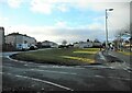
Amenity grassland
An oblong of amenity grassland between Ashgill Road (on the right) and Harmetray Street (on the left)
Image: © Richard Sutcliffe
Taken: 19 Jan 2023
0.06 miles
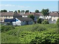
2

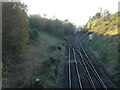
Disused railway line
A cutting beneath Ashfield Street which has become overgrown or an informal landfill.
Image: © Richard Webb
Taken: 9 May 2012
0.07 miles
3

Chirnsyde Primary School
On Ashgill Road. An early post-World War II primary school. It is Category B listed http://portal.historicenvironment.scot/designation/LB33735.
Image: © Richard Sutcliffe
Taken: 19 Jan 2023
0.09 miles
4
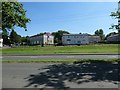
Houses on Eday and Harmetray Streets, Glasgow
Developed since World War Two.
Image: © Christine Johnstone
Taken: 26 Jun 2019
0.09 miles
5

Dismantled railway, west of Ashfield Street, Glasgow
The former Lanarkshire and Dumbartonshire section [LMSR], just west of the former Possil Junction.
Image: © Christine Johnstone
Taken: 26 Jun 2019
0.12 miles
6
Milton Dental Clinic, Glasgow
At the east end of Haywood Street.
Image: © Christine Johnstone
Taken: 26 Jun 2019
0.13 miles

8

Burst Water Main
Ashfield Street, Possil Park
Image: © Chris Upson
Taken: 6 Sep 2005
0.14 miles
10
Ashfield Approach
A diesel commuter train calls at Ashfield station on a reopened section of track providing passenger services to Maryhill and Anniesland. The crossover provides a connection to the northbound main line to Bishopbriggs and beyond.
Image: © Raymond Okonski
Taken: 19 Oct 2007
0.15 miles