IMAGES TAKEN NEAR TO
Maryhill Road, GLASGOW, G20 0SJ
Introduction
This page details the photographs taken nearby to Maryhill Road, G20 0SJ by members of the Geograph project.
The Geograph project started in 2005 with the aim of publishing, organising and preserving representative images for every square kilometre of Great Britain, Ireland and the Isle of Man.

There are currently over 7.5m images from over14,400 individuals and you can help contribute to the project by visiting https://www.geograph.org.uk
Image Map
Images are licensed for reuse under creativecommons.org/licenses/by-sa/2.0
Notes
- Clicking on the map will re-center to the selected point.
- The higher the marker number, the further away the image location is from the centre of the postcode.
Image Listing (88 Images Found)
Images are licensed for reuse under creativecommons.org/licenses/by-sa/2.0
Image
Details
Distance
1
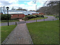
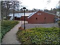
Block 3, Kelvin Campus
One of 9 blocks within the Kelvin Campus of the University of Glasgow at Garscube Estate.
Image: © Richard Sutcliffe
Taken: 9 Apr 2022
0.01 miles
2
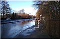
Flooding on Maryhill Road
Following heavy overnight rain, this part of Maryhill Road was flooded. The large puddle coincided with the bus stop, meaning that anybody waiting for the bus was forced to stand several metres away from the bus stop in order to avoid the spray from passing vehicles, some of which slowed down, some of which did not!
Image: © Richard Sutcliffe
Taken: 12 Jan 2020
0.04 miles
3
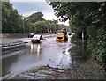
Flooded road
Council workers attempting to clear the drains on the A81, Maryhill Road, after the road had flooded. This photograph was taken about 24 hours after the road had flooded due to a torrential downpour which affected a wide area of northwest Glasgow, Bearsden and Milngavie. Most of the other floods on other roads had drained away, but this one was obviously causing a problem. Vehicles heading for Glasgow were having to go through several inches of water and many were driving half on the central reservation of the dual carriageway.
Image: © Richard Sutcliffe
Taken: 10 Aug 2021
0.05 miles
4
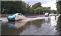
Flooded road
A car passes a Council worker attempting to clear the drains on the A81, Maryhill Road, after the road had flooded. This photograph was taken about 24 hours after the road had flooded due to a torrential downpour which affected a wide area of northwest Glasgow, Bearsden and Milngavie. Most of the other floods on other roads had drained away, but this one was obviously causing a problem. Vehicles heading for Glasgow were having to go through several inches of water and many were driving half on the central reservation of the dual carriageway.
Image: © Richard Sutcliffe
Taken: 10 Aug 2021
0.05 miles
5
After the flood
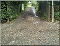
The entrance to Garscube Allotments on Maryhill Road. Torrential rain the previous day had seen large volumes of water pouring down the slope out of the allotments, eroding the track and depositing a significant amount of gravel from it onto the road and pavement.
Image: © Richard Sutcliffe
Taken: 10 Aug 2021
0.06 miles
6
Block 2, Kelvin Campus
One of 9 blocks within the Kelvin Campus of the University of Glasgow at Garscube Estate.
Image: © Richard Sutcliffe
Taken: 9 Apr 2022
0.07 miles
7
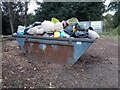
There's a body in the skip!
In the car park at Garscube Allotments. I wonder which plot holder bears responsibility?
Image: © Richard Sutcliffe
Taken: 10 Sep 2024
0.07 miles
8
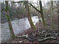
Dead wood beside the river
Branches from a nearby felled tree have been left beside the bank of the River Kelvin, for the benefit of wildlife.
Image: © Richard Sutcliffe
Taken: 8 Jan 2023
0.08 miles
9
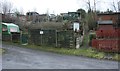
Garscube Allotments
All quiet around midday on New Year's Day.
Image: © Richard Sutcliffe
Taken: 1 Jan 2020
0.08 miles
10
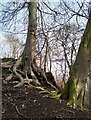
Hanging on
The roots of a beech tree managing to support it on a steep slope with a shallow soil.
Image: © Richard Sutcliffe
Taken: 8 Jan 2023
0.08 miles