IMAGES TAKEN NEAR TO
Glanderston Drive, GLASGOW, G13 3UG
Introduction
This page details the photographs taken nearby to Glanderston Drive, G13 3UG by members of the Geograph project.
The Geograph project started in 2005 with the aim of publishing, organising and preserving representative images for every square kilometre of Great Britain, Ireland and the Isle of Man.

There are currently over 7.5m images from over14,400 individuals and you can help contribute to the project by visiting https://www.geograph.org.uk
Image Map
Images are licensed for reuse under creativecommons.org/licenses/by-sa/2.0
Notes
- Clicking on the map will re-center to the selected point.
- The higher the marker number, the further away the image location is from the centre of the postcode.
Image Listing (16 Images Found)
Images are licensed for reuse under creativecommons.org/licenses/by-sa/2.0
Image
Details
Distance
1
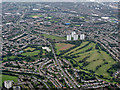
Knightswood from the air
Knightswood golf course is prominent, Scotstoun Stadium is at the top right and the A82 Great Western Road is towards the top left. The towerblocks in the centre are on Lincoln Avenue.
Image: © Thomas Nugent
Taken: 14 Sep 2015
0.14 miles
2

Former ARP Station
On Kingfisher Drive. See also Image
Image: © Thomas Nugent
Taken: 18 May 2008
0.15 miles
3

Former ARP station
Now converted to housing, on Kingfisher Drive, Garscadden. See also Image
Image: © Thomas Nugent
Taken: 18 May 2008
0.15 miles
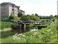
4
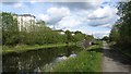
Forth and Clyde canal near Blairdardie
The picture looks west along the canal from the bascule bridge Image
Image: © Alec MacKinnon
Taken: 1 Jun 2022
0.18 miles
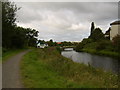
5
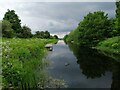
Forth Clyde Canal
Passing Old Drumchapel.
Image: © Richard Webb
Taken: 9 May 2012
0.19 miles
8

Knightswood Golf Course
Knightswood Golf Course is located just four miles west of Glasgow city centre. It is a 9 hole flat and open parkland course.
The Campsie Fells can be seen in the distance to the right in the photograph. To the left in the distance, a small part of the Kilpatrick Hills can also be seen between 2 of the tower blocks.
Image: © G Laird
Taken: 20 Mar 2010
0.21 miles
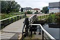
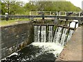
10
Blairdardie bascule bridge
Built in 1790 on the Forth and Clyde canal.
Image: © william craig
Taken: 10 Jun 2005
0.22 miles