IMAGES TAKEN NEAR TO
Stronachlachar, STIRLING, FK8 3TX
Introduction
This page details the photographs taken nearby to FK8 3TX by members of the Geograph project.
The Geograph project started in 2005 with the aim of publishing, organising and preserving representative images for every square kilometre of Great Britain, Ireland and the Isle of Man.

There are currently over 7.5m images from over14,400 individuals and you can help contribute to the project by visiting https://www.geograph.org.uk
Image Map
Images are licensed for reuse under creativecommons.org/licenses/by-sa/2.0
Notes
- Clicking on the map will re-center to the selected point.
- The higher the marker number, the further away the image location is from the centre of the postcode.
Image Listing (10 Images Found)
Images are licensed for reuse under creativecommons.org/licenses/by-sa/2.0
Image
Details
Distance
1
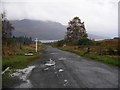
Road to Stronachlachar
From the T-junction on the B 829 road, looking W towards Loch Katrine
Image: © Chris Eilbeck
Taken: 29 Oct 2005
0.03 miles
2
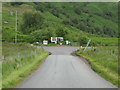
T-junction at the end of the B829
The B829 becomes a minor road at this point, left leading to Inversnaid (Loch Lomond) and right leading to Stronachlachar (Loch Katrine). Both roads are dead-ends.
Image: © G Laird
Taken: 28 Jun 2017
0.04 miles
3
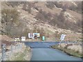
Looking into Stirlingshire
Assorted signs at the end of the B829. An unusual occurrence of looking north from Perthshire into Stirlingshire (all governed by Stirling Council now).
Image: © Richard Webb
Taken: 24 Apr 2016
0.04 miles
4
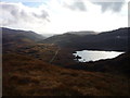
Loch Arklet and the road to Aberfoyle
From the hillside of Garradh, above Stronachlachar
Image: © Alan O'Dowd
Taken: 5 Nov 2011
0.10 miles
5
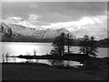
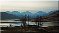
Loch Arklet On A March Late Afternoon
Shot in monochrome, the beauty of this particular corner of Stirlingshire is self-evident. The structure within the trees in the foreground is the aqueduct intake to transfer water to Loch Katrine.
Image: © James T M Towill
Taken: 22 Mar 2017
0.21 miles
6
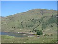
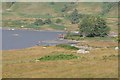
Head of Loch Arklet
View to the now greening up slopes of Maol Mòr. Loch Arklet is drawn down like a hydro electric loch, but is one of Glasgow's water supply reservoirs. Its water flows into Loch Katrine which was topped up on this occasion.
Image: © Richard Webb
Taken: 27 May 2012
0.21 miles
7
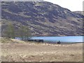
Loch Arklet
Aqueduct inlet feeding water from the reservoir into Loch Katrine just south of Stronachlachar
Image: © John Myers
Taken: 16 Apr 2014
0.22 miles
8
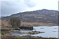
Loch Arklet
The aqueduct inlet at the east end.
Image: © Richard Webb
Taken: 24 Apr 2016
0.23 miles
9
Trees by the aqueduct intake on Loch Arklet
Image: © Peter Moore
Taken: 28 Feb 2016
0.23 miles
10
Loch Arklet aqueduct
This is the aqueduct intake from Loch Arklet, which feeds water eastwards into Loch Katrine. Both lochs contribute to the Glasgow city water supply.
Image: © John Gibson
Taken: 23 Sep 2007
0.24 miles