
IMAGES TAKEN NEAR TO
Ramsay Place, STIRLING, FK8 1AG
Introduction
This page details the photographs taken nearby to Ramsay Place, FK8 1AG by members of the Geograph project.
The Geograph project started in 2005 with the aim of publishing, organising and preserving representative images for every square kilometre of Great Britain, Ireland and the Isle of Man.

There are currently over 7.5m images from over14,400 individuals and you can help contribute to the project by visiting https://www.geograph.org.uk
Image Map
Images are licensed for reuse under creativecommons.org/licenses/by-sa/2.0
Notes
- Clicking on the map will re-center to the selected point.
- The higher the marker number, the further away the image location is from the centre of the postcode.
Image Listing (86 Images Found)
Images are licensed for reuse under creativecommons.org/licenses/by-sa/2.0
Image
Details
Distance
1
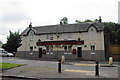
Back O'Hill
A pub on the edge of Raploch.
Image: © Bill Boaden
Taken: 9 Aug 2013
0.05 miles
2
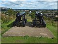
Cannons on Mote Hill
They are just a few metres to the south of Image, as shown in Image They are also shown in Image
For the skyline hills behind the left cannon, and other background details, see the comments at Image
Image: © Lairich Rig
Taken: 25 Aug 2018
0.11 miles
3
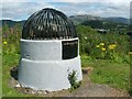
The Beheading Stone
In the background, on the right, is the Wallace Monument on the Abbey Craig.
For more about the stone, and for more context, see Image, which I took on the same occasion.
For other views, see Image / Image (with useful links) / Image
The inscription on the plaque is as follows: "The Beheading Stone: Protected by the public at the instance of the Stirling Natural History & Archaeological Society / 1887".
The stone, long before it was enclosed in the present structure (which is the work of John Allan), was mentioned by William Nimmo in his 1777 "History of Stirlingshire". I cannot vouch for his historical accuracy, but merely quote the relevant passages below for interest.
From page 252: "Opposite to the castle, upon the north, lies the Gowan Hill, upon which is a stone, with an inscription, but it is unintelligible, nor does it appear, from the form of the letters, to be of any great antiquity. Upon the northern extremity of this hill, near the bridge, is a small mount, well known in the neighbourhood by the uncouth name of Hurly-Haaky, surrounded at the top with a parapet of earth, and having other remains of artificial works upon it. Upon this mount, Duncan Earl of Lennox, with his son-in-law, Murdoch Duke of Albany, who had been sometime governor of the realm, was beheaded, May 18th 1425, as were Walter and Alexander Stewarts, sons of that Duke, the day following".
On page 255 of the same work, Nimmo mentions this location again, stating that "it is highly probable, that Hurly Haaky was the mote hill of the castle of Stirling, or perhaps of a much larger jurisdiction".
For the meaning of "mote hill" (or "moot hill"), compare Image, Image, and the final few paragraphs at Image
The name "Gowan Hills" was formerly applied to what is now Gowan Hill, Mote Hill, and the part that was later reshaped to form Ballengeich Cemetery. That earlier usage is reflected in the quotation from p252 of Nimmo, above.
Image: © Lairich Rig
Taken: 22 Jul 2008
0.11 miles
4
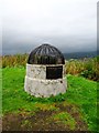
Stirling, Mote Hill
See RCAHMS record http://canmore.rcahms.gov.uk/en/site/46206/details/stirling+mote+hill/
and http://canmore.rcahms.gov.uk/en/site/46234/details/stirling+gowanhill+the+beheading+stone/ for the Beheading Stone.
Image: © Robert Murray
Taken: 11 Sep 2011
0.11 miles
5
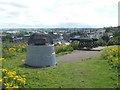
Cannons and the Beheading Stone on Mote Hill
For more on the Beheading Stone, see Image and Image (the latter has a very useful link to Canmore's entry on Mote Hill).
The structure containing the stone has a plaque on the far side. For a view from that side, for the text of the plaque, and for comments by the eighteenth-century historian William Nimmo that explain the name of the stone, see Image, which was taken on the same occasion as the present photograph.
Gowan Hill is nearby. The high ground here was formerly known as the Gowan Hills, embracing what is now Mote Hill, Gowan Hill, and the part that was subsequently reshaped to form Ballengeich Cemetery.
In past centuries, Gowan Hill was, according to a nearby information panel, the scene of an unusual form of sledging. King James V, born in 1512, and king from 1513-42 (regents ruled Scotland during his childhood) is thought to have played Hurley Hawkie here as a boy (or "Hurly Haaky" – see the Canmore link mentioned above for more on this; see also the headword "Hurlie-Hacket" — https://dsl.ac.uk/entry/snd/hurliehacket — in the Dictionary of the Scots Language). This pastime, which was played here for centuries, involved sliding down the steep hill (here, supposedly, this was done while sitting on a cow's skull, using its horns as handlebars; in an agricultural market town like Stirling, skulls were readily available). In any case, it is thought that the name of the pastime was transferred to the hill.
Image: © Lairich Rig
Taken: 22 Jul 2008
0.11 miles
6
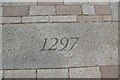
Battle of Stirling Bridge Stone
A stone laid in the ground in the shadow of the auld brig of Stirling to commemorate the battle in 1297 when the Scots army led by William Wallace (later knighted) and Sir Andrew Moray defeated a much larger English army of invasion.
http://en.wikipedia.org/wiki/Battle_of_Stirling_Bridge
Image: © Robert Murray
Taken: 24 Sep 2008
0.11 miles

8
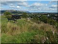
Mote Hill: eastern side of the ancient fort
This is the opposite view to Image, in which the same bench appears. For the cannons, see Image
The present view is along the course of the bank that is probably the line of the fort's wall. On the near side of the bench is a groove that heads off to the right, down the slope; this perhaps corresponds to the entrance of the fort. See the Canmore link in the end-note for further details.
For the hills on the skyline, see Image, taken from the other side of the summit.
Image: © Lairich Rig
Taken: 25 Aug 2018
0.11 miles
9
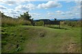
Mote Hill: western side of the ancient fort
This is the western side of the summit. What looks like a linear mound crossing the image from left to right, on the near side of the bench, may be part of the outline of the fort described at the Canmore link given in the end-note.
The view is from the interior of the fort, looking out across its wall. See Image for further possible traces on the opposite side of the summit.
The prominent skyline hill near the right-hand edge of the present picture is Ben Ledi (Image).
Image: © Lairich Rig
Taken: 25 Aug 2018
0.11 miles
10
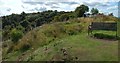
Mote Hill: eastern side of the ancient fort
This is the eastern side of the summit of Mote Hill. The faint outline of a fort can be discerned along the eastern, southern and western edges of the summit, though it is often hard to see because of the vegetation.
The present view is from beside two cannons that are set on the summit (Image); I have included the bench in the picture as a readily identifiable point of reference. The wall of the fort begins by receding directly from view; in the background, it gradually curves away to the right.
Beginning just behind the bench, and then heading left, down the slope, is a sort of groove, which perhaps corresponds to the original entrance of the fort: see the Canmore link in the end-note for further details. For a view in the opposite direction over this feature, see Image
See Image for other possible traces of the fort's wall, on the opposite side of the summit. On this occasion, the southern side of the summit was too overgrown to allow anything useful to be shown in a photograph, and the northern side was even more so.
Image: © Lairich Rig
Taken: 25 Aug 2018
0.11 miles